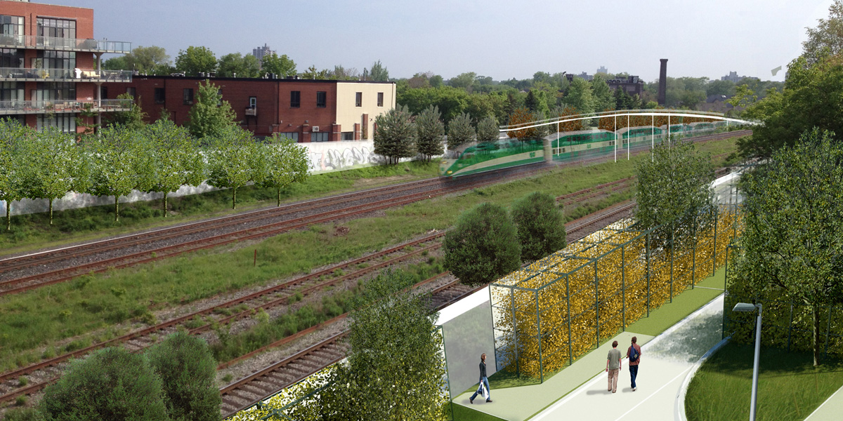
Linear Networks – The Railway

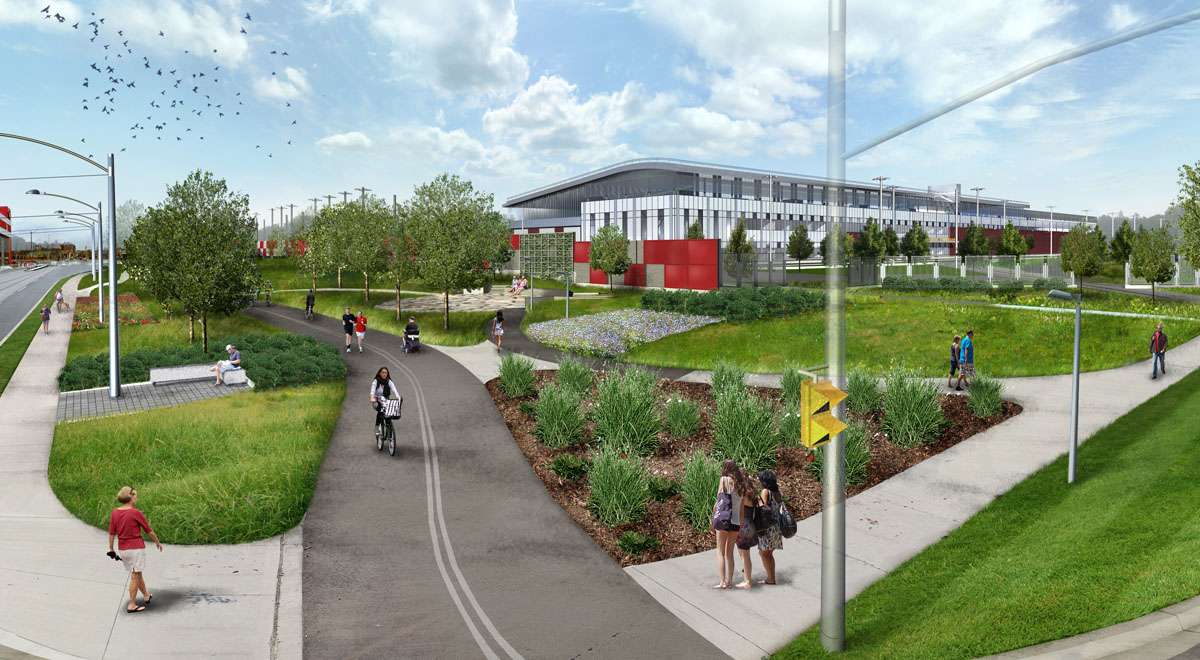
In a city that seems to still be divided into its pre-amalgamated entities, linear networks like Toronto’s rail corridors present an opportunity to forge new connections that cross geographical and political perceived boundaries. The rail …

The dramatic potential of the Nordhavnen site for a new vibrant and ecologically sound extension of Copenhagen has shaped our proposal. We planned the city as a thick and dense longitudinal cluster along a new subway line with a direct …

Existing Conditions on Parkside Drive

Parkside Drive is rightfully the subject of serious neighbourhood concern. With its asymmetrical relationship to its two sides, Parkside Drive is highly divisive, and with its high-speed traffic, there is no safe public realm. Parkside …

A client in Toronto’s west end commissioned Brown and Storey Architects to create a laneway house proposal.

Rendered Views

Section, Plan and Elevations

 …

In our Dufferin Grove Community Project completed over twenty years ago, we identified Dufferin Grove as a city park in need of re-thinking. Given the last two years of the pandemic, parks and park users have become more entwined in …

The various building options are meant to illustrate the flexibility of built and open space configurations for the Warden development site.  In particular the template organization promotes the open void and public spaces, while, at the same time, establishing vertical …

Brown and Storey Architects and Richard Gilbert were engaged by the City of Toronto Department of Economic Development, Culture and Tourism to provide a Capital Works and Development Strategy for St. Clair Avenue West. This part of St. Clair extends …

Brown and Storey Architects perform many different types of architectural and urban design initiatives in which there are no client or commission; we work with a range of community groups and organizations that enable us to create solutions aimed at

Introduction

Our approach to the challenge of public electric car charging infrastructure along major highways treats the travelers as agential activators, engaging with technology, media, culture, and landscape. As much as the structures are architectural, they are apparatuses and instruments …

This Project introduces new spatial models for living together that offers direct involvement by the residents in the production and control of their space. The urban narratives of cultural and physical landforms come together in a shared landscape of garden …

Between 1932 and 1933, Ukraine suffered a famine affecting the major grain-producing areas in the region. The famine, known as the Holodomor, was a result of forced collectivization, a policy that was deliberately planned and executed by the Soviet regime …

Brown + Storey Architects Inc. worked with CreateTO to create a comprehensive plan for the redevelopment of Leslie Street. The redevelopment includes a proposal for the ‘Look-out Park’, a park at the end of the Lehigh Shipping Channel on the …

A conceptual rendering of upcoming streetscape improvements for Belleville's historic Front Street.

The City of Belleville has embarked on a forward-looking project to update the infrastructure of their historic downtown core. The project, which is upgrading and replacing both sub-surface utilities and the public infrastructure of the city’s downtown streets and open …

The Ashbridges Perimeter Landscape will add public space and improve the Martin Goodman Trail, seen here looking north on Leslie St. towards Lake Shore Blvd.

Brown + Storey Architects Inc. was the winner of a 2010 competition to design a perimeter landscape and linear park to surround the new TTC Streetcar Maintenance and Storage Facility near Leslie Street and Lake Shore Boulevard, opening in 2015. …

Rendering of B+SA's alternative proposal for the boundaries of Metrolinx's Georgetown South Corridor Expansion, promoting the use of new trees, living walls, and new trails and linear parks to soften the corridor's impact on neighbourhoods.

Metrolinx is expanding its commuter rail corridor through West Toronto in order to provide capacity for the Union-Pearson Express air-rail link and expanded GO Transit service to Georgetown, Guelph and Kitchener. The corridor passes through mature neighbourhoods and present-day brownfield …

Our proposal envisions sequences of semi-enclosed rooms created by structured hedges. Safe views to the adjacent rail corridor are maintained in the gaps between sections of green wall.
Our Green Line Competition A entry proposed a sequence of structured open spaces along the linear corridor created by Toronto's crosstown freight lines.

Morrow Park is Peterborough’s large agricultural fairground, hosting an annual summer horticultural fair. This large 27 acre park is located on the main approach to the city and forms a prominent entrance to the downtown core. It is home to …

Brown + Storey Architects Inc. worked as part of a team hired by Terrasan Environmental Solutions to prepare a master plan-level development proposal for Brantford’s Greenwich Mohawk brownfield site, a 50-acre former industrial district that once hosted factories operated by …

The West Toronto Railpath has transformed two kilometres of railway spur line that served Toronto’s west end industries during the 19th and 20th centuries, with a new linear open space supporting a cycling and pedestrian multi-trail. The path is punctuated …

Conceptual Streetscape Design for Richmond Street (2008)

In 2008, our office was commissioned to produce a conceptual design for the improvement of the streetscape on Richmond Street West, just east of Spadina Avenue. This section of one-way street had evolved from an industrial access road -turned- commuter …

Rendered Master Plan for a revitalized King's Navy Yard Park.

The town of Amherstburg and its historic fort Malden are located on the Detroit River at the extreme western edge of Ontario in the county of Essex. They long history of Amherstburg, with its involvement in the war of 1812, …

Occupying a small site between condominiums in a rapidly changing downtown neighbourhood, Massey Harris Park was built to be a local gathering spot for young and old as well as a way to get from one point to another.

Jean Sibelius Park is a modest and compact park located in an older neighbourhood of Toronto. Over time, the recreational uses of the park and its current spatial allocations became a source of conflict among a greater diversity of users. …

BROWN+STOREY were key contributors to the now-completed Bloor Street Transformation that has revitalized and improved the pedestrian realm of one of Toronto's signature retail avenues.

Yonge + Dundas Square was conceived as a new civic space in the centre of downtown Toronto.  It is located at the crossroads of Yonge Street and Dundas Street, one of the most prominent intersections in the city.  The project …

Titled “A Creative Landscape for Making a Living,” Brown + Storey Architects’ Master Plan for upgrading the pedestrian realm along a key stretch of Toronto’s College Street transformed a city plan for status quo replacement into a successful enhancement program. …

Brown and Storey Architects were one of five finalist teams chosen from 180 international submissions to design a new metropolitan park for the 320 acre site that was formerly the Canadian Forces Base Downsview.

Trinity-Bellwoods Park is one of Toronto’s most beloved and heavily used open spaces, accommodating thousands of daily visitors in all seasons. With St. Hilda’s Walk, Brown + Storey Architects Inc. with City of Toronto Parks and community stakeholders to convert

The revitalization of St. George Street, a main thoroughfare of the University of Toronto and a major traffic artery in the City of Toronto, was commissioned by the University and the City to bring improvements to what had once been …

Brown + Storey Architects Inc. were commissioned by the City of Toronto in 1991 to produce a typological classification of public open spaces in the downtown core. ‘The Open Spaces of Toronto – A Classification’ encompasses:

  1. developing definitions and criteria