
Paradise Patchwork – Neighbourhoods for Generations
Building on their original housing and urban design work for Victoria Park Avenue and the Victoria Park Subway Station, Brown + Storey Architects further developed their proposal for the Taylor Massey community in the Neighbourhoods for Generations Competition in March, 2023. The proposal, “Paradise Patchwork, ” is inspired by the firm’s Un-Avenues research, which explores opportunities to intensify existing north-south arterial roads in Toronto’s Yellowbelt—areas of the city with highly restrictive zoning laws. Their research presents solutions to the housing crisis that radically alter the relationship between existing established neighbourhoods, multi-family housing, and connectivity between urban block configurations.
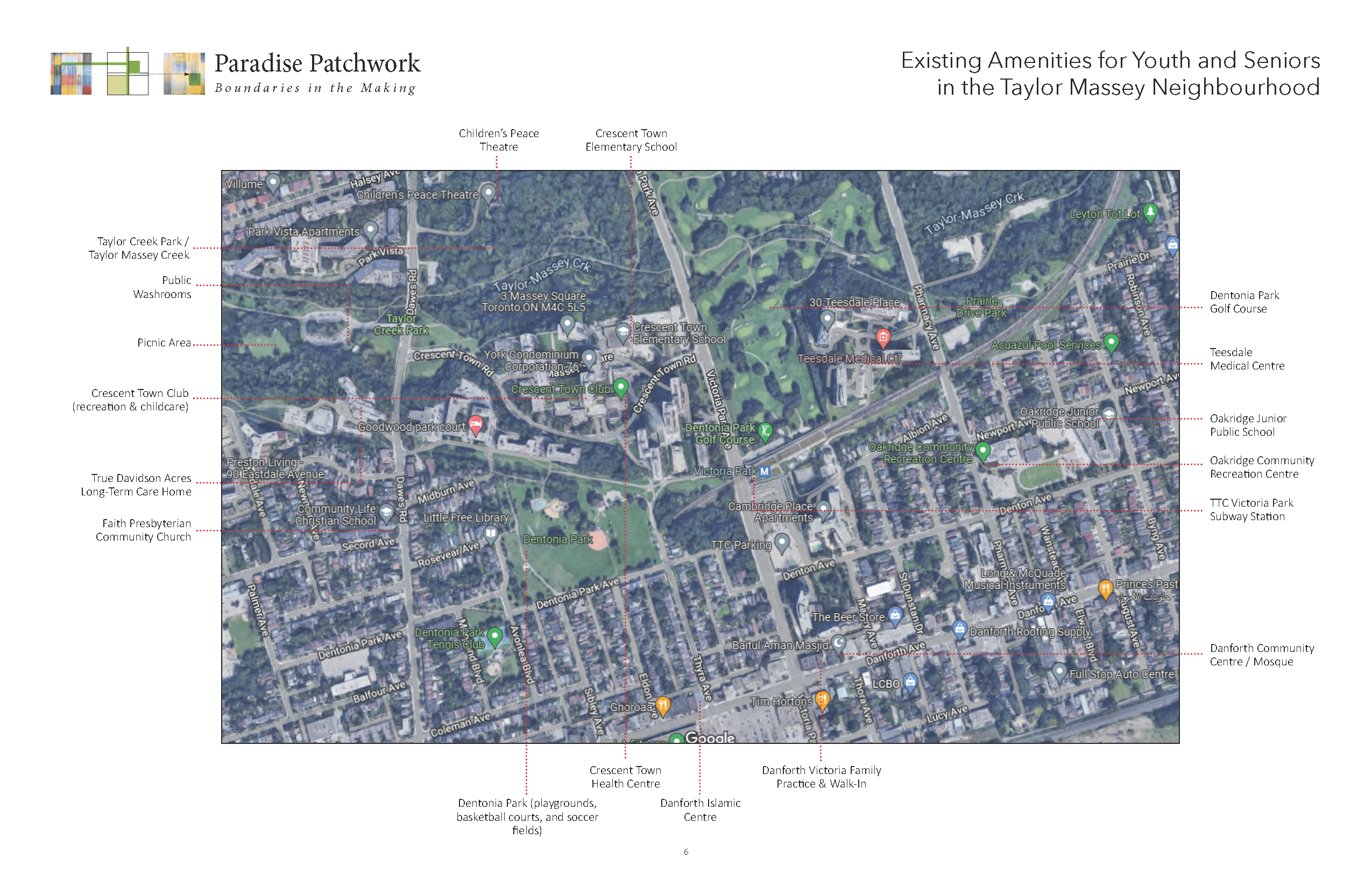
Located along a trio of isolated traffic corridors in Toronto are groupings of high-density tower communities known as Crescent Town, Teesdale Place, and Pharmacy Place. Built in the 1970’s as self-contained “towns,” the tower groupings are highly isolated— from the street, from one another, from the adjacent single-family neighbourhoods, and from the surrounding parks and natural systems. We believe that there is tremendous opportunity in this under-realized, under-connected neighbourhood to create a “Patchwork Paradise,” a new system of mixed-use apartments and connective infrastructure that will foster a vibrant, inter-woven neighbourhood for generations.
- Read the competition project summary here: Paradise Patchwork Submission
- View the competition panels here: Paradise Patchwork Panels
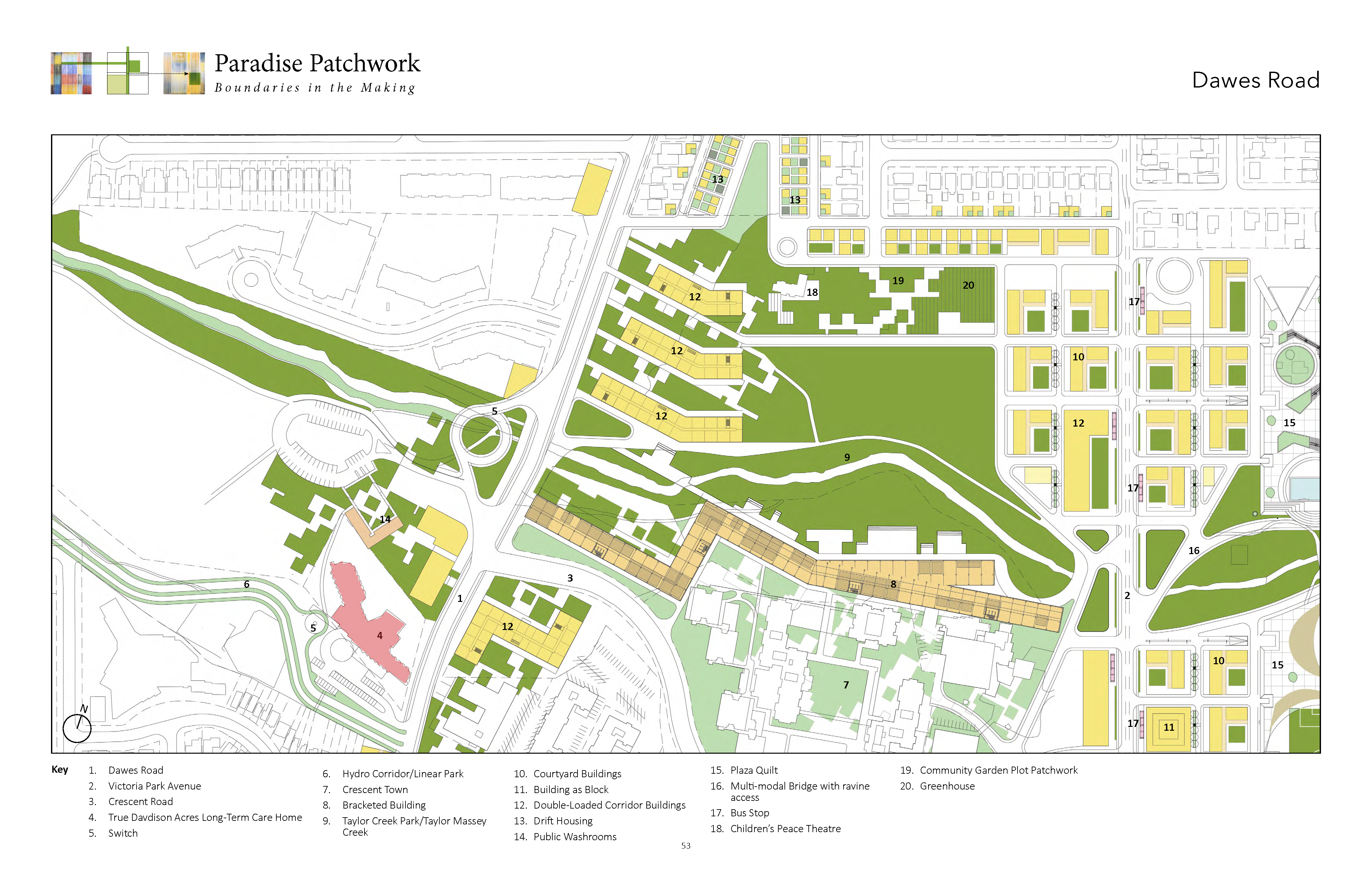
Patchwork Paradise: Creating a vibrant, age-friendly community along Dawes Road, Victoria Park Avenue, and Pharmacy Avenue
A Democratic Patchwork Matrix: A decentralized organization
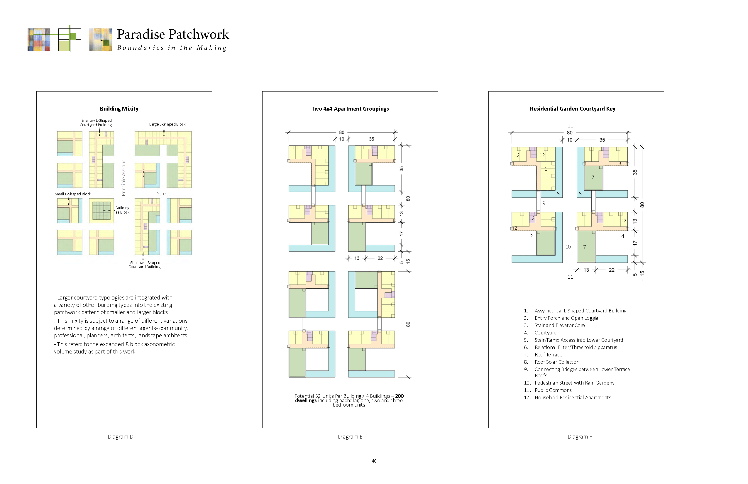
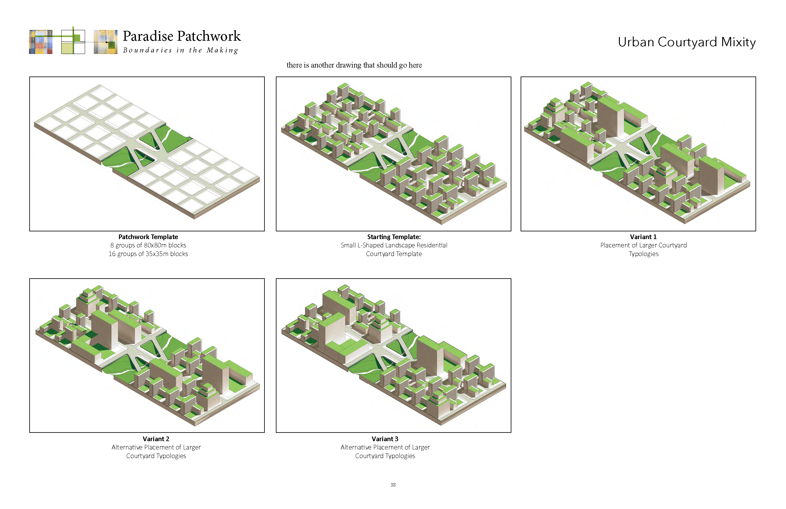
The patchwork quilt organization is a framework for interpretations and agential possibilities in a porous suburban density. The patchwork is based on an 80×80-metre block idea. This dimension of the block is combined with a pedestrian street dimension of 10-metres that subdivides the block into streets and four smaller sub-blocks and between the larger blocks are 25-metre-wide commons. The non-overlapping quilt of patches is capable of both subdivision and expansion of its metric in order to accommodate a range of buildings and open space typologies.
For the current roads to become streets, this matrix patch dynamic is positioned on both sides of the street, oriented in a north south direction. The matrix aligns across the 30-metre right-of-way on of each of the streets. The basic typology of framed L-shaped open courtyards orient themselves facing south and the framing buildings provide a northern formed protection against prevailing north winds. The courtyard matrix is a relational and democratic organization that interacts with its surrounding buildings and open spaces. The matrix can expand horizontally and vertically. At the subdivision of the larger block into four smaller blocks, these blocks are provided with a two-sided threshold or transitional space.
Patch Dynamics: A Shifting Mosaic
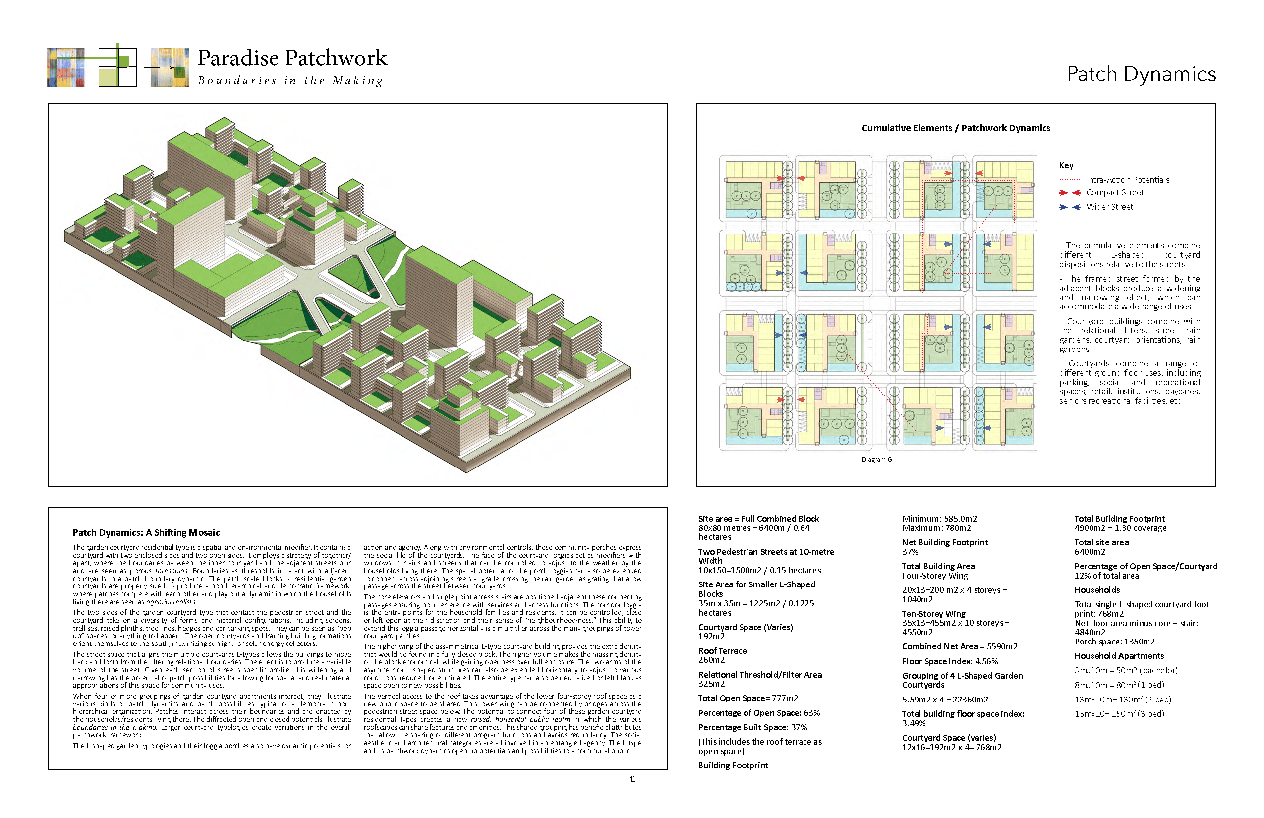
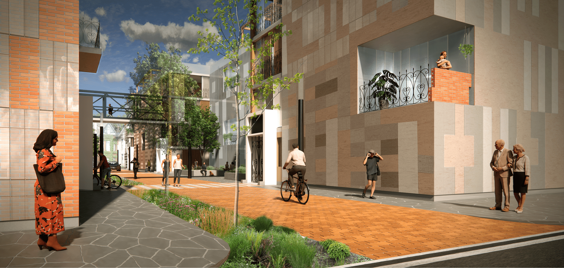
The garden courtyard residential type is a spatial and environmental modifier. It contains a courtyard with two enclosed sides and two open sides. It employs a strategy of together/apart, where the boundaries between the inner courtyard and the adjacent streets blur and are seen as porous thresholds. Boundaries as thresholds intra-act with adjacent courtyards in a patch boundary dynamic. The patch scale blocks of residential garden courtyards are properly sized to produce a non-hierarchical and democratic framework, where patches compete with each other and play out a dynamic in which the households living there are seen as agential realists.
The two sides of the garden courtyard type that contact the pedestrian street and the courtyard take on a diversity of forms and material configurations, including screens, trellises, raised plinths, tree lines, hedges and car parking spots. They can be seen as “pop up” spaces for anything to happen. The open courtyards and framing building formations orient themselves to the south, maximizing sunlight for solar energy collectors. The street space that aligns the multiple courtyards L-types allows the buildings to move back and forth from the filtering relational boundaries. The effect is to produce a variable volume of the street. Given each section of street’s specific profile, this widening and narrowing has the potential of patch possibilities for allowing for spatial and real material appropriations of this space for community uses.
When four or more groupings of garden courtyard apartments interact, they illustrate various kinds of patch dynamics and patch possibilities typical of a democratic non-hierarchical organization. Patches interact across their boundaries and are enacted by the households/residents living there. The diffracted open and closed potentials illustrate boundaries in the making. Larger courtyard typologies create variations in the overall patchwork framework.
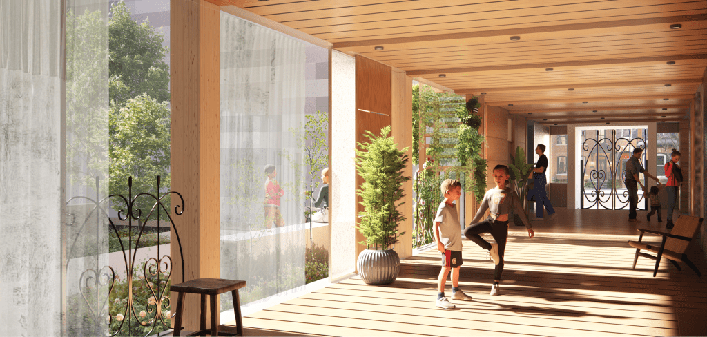
The L-shaped garden typologies and their loggia porches also have dynamic potentials for action and agency. Along with environmental controls, these community porches express the social life of the courtyards. The face of the courtyard loggias act as modifiers with windows, curtains and screens that can be controlled to adjust to the weather by the households living there. The spatial potential of the porch loggias can also be extended to connect across adjoining streets at grade, crossing the rain garden as grating that allow passage across the street between courtyards.
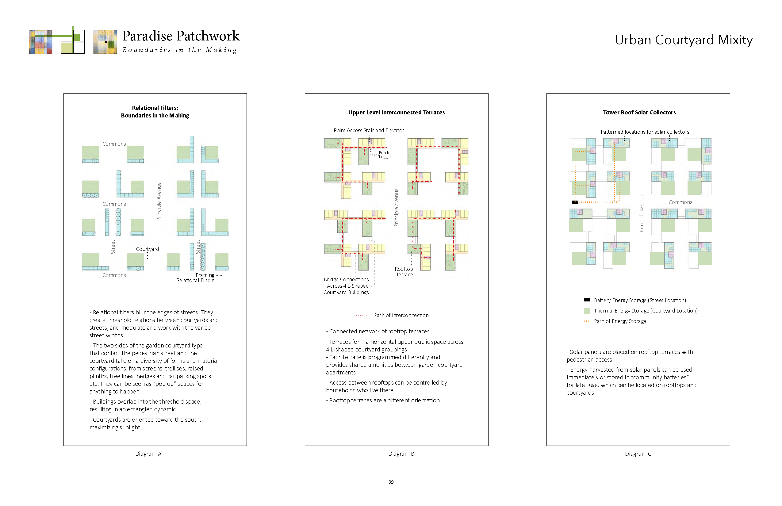
The elevators and single-point-access stairs are positioned adjacent these connecting passages ensuring no interference with services and access functions. The corridor loggia is the entry points for the household families and residents, it can be controlled, close or left open at their discretion and their sense of “neighbourhood-ness.” This ability to extend this loggia passage horizontally is a multiplier across the many groupings of tower courtyard patches.
The higher wing of the asymmetrical L-type courtyard building provides the extra density that would be found in a fully closed block. The higher volume makes the massing density of the block economical, while gaining openness over full enclosure. The two arms of the asymmetrical L-shaped structures can also be extended horizontally to adjust to various conditions, reduced, or eliminated. The entire type can also be neutralized or left blank as space open to new possibilities.
The vertical access to the roof takes advantage of the lower four-storey roof space as a new public space to be shared. This lower wing can be connected by bridges across the pedestrian street space below. The potential to connect four of these garden courtyard residential types creates a new raised, horizontal public realm in which the various roofscapes can share features and amenities. This shared grouping has beneficial attributes that allow the sharing of different program functions and avoids redundancy. The social aesthetic and architectural categories are all involved in an entangled agency. The L-type and its patchwork dynamics open up potentials and possibilities to a communal public.
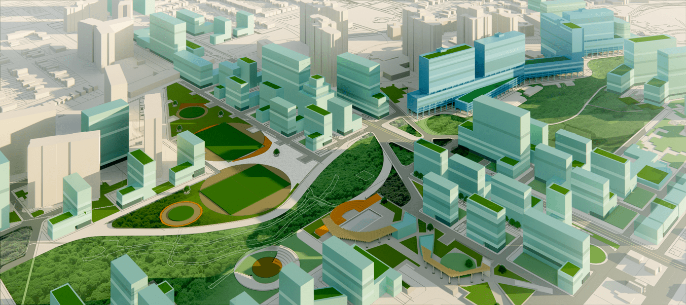
This site can better connect to the adjacent residential blocks that form its perimeter and the city at large. Currently, these blocks are unfinished and broken, with backyards unceremoniously fronting onto the major green space. These areas need to be recharged with new frontages and small typologies that form a connected and workable new threshold space. In turn, the three existing high-rise aggregates are re-introduced to a range of new typologies, including small courtyard typologies, larger-scale buildings, and connective infrastructure that form part of a larger, unified, age-friendly neighbourhood.
Pedestrian Bridges over the Ravine
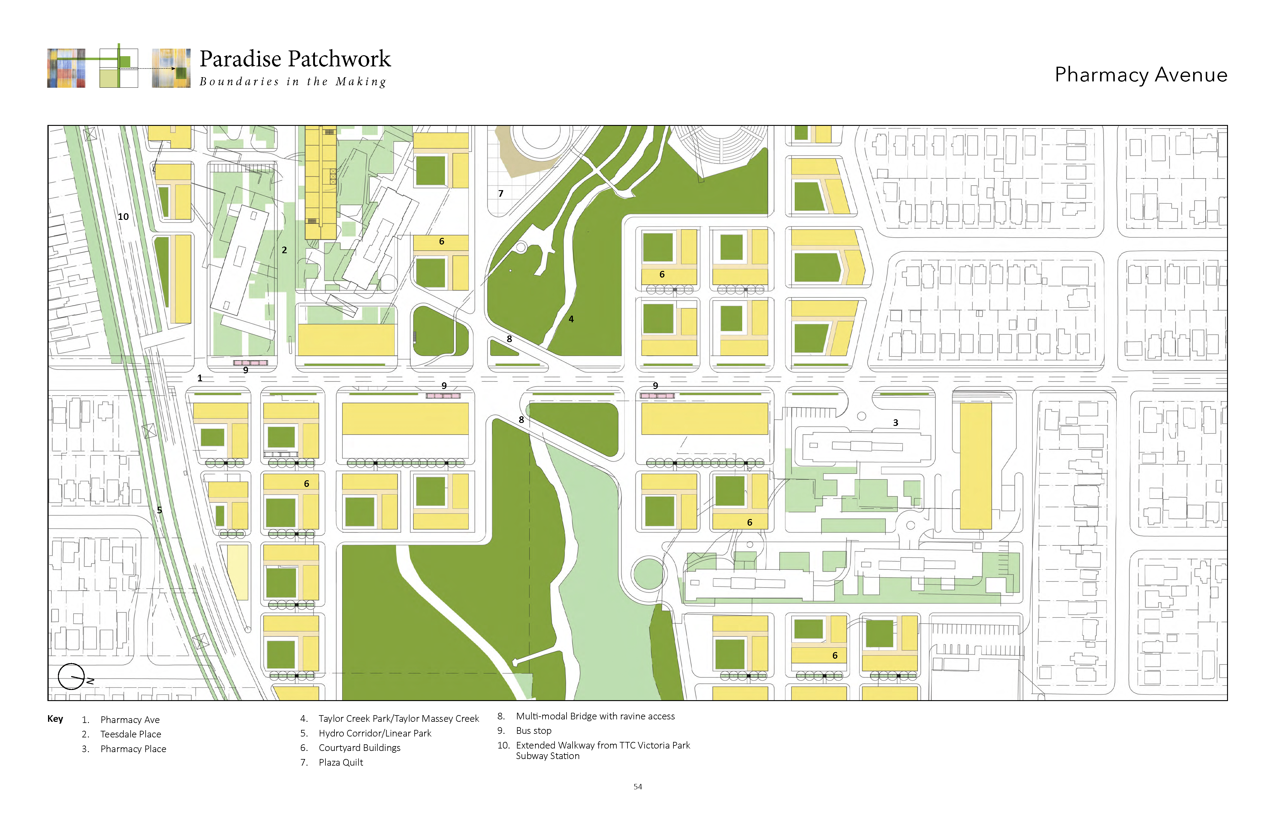
Pharmacy Avenue’s bridge is one of three bridge locations that achieve a wide range of goals. The bridges are infrastructure that can connect the new streets to the ravine as well connect to the three large slab/high-rise neighbourhoods by providing linkages. The Pharmacy bridge connects to Teesdale and Pharmacy Place, bringing both of these communities into contact with each other as well as direct links into the adjacent large green space. Presently all these streets exist more as roadways than as streets, and consequently pass over Massey Creek, hidden and invisible. Segments of the bridges extend out to connect to adjacent new streets and locations within the slab tower groupings. Each bridge is distinctive and acts locally to find the best locations to entwine the bridge into adjacent towers and open spaces, providing needed new relationships and eliminating the separated and internalized situations of the towers/slabs.
Pharmacy Place Teesdale and East Teesdale Extension
When combined with the double strip of new blocks fronting Pharmacy, all three of the existing tower neighbourhoods take on a more unified pattern. A new tower located at the top of Pharmacy Place starts to illustrate a spread of towers integrating with the existing towers. There is a block of 5 towers and low structures that concentrate and frame the bridge crossings. There is a route/linkage that comes from the north end of Pharmacy place south of the bridge, crosses at the bridge links into Teesdale and then connects further south to the walkway paralleling the subway line to connect directly to the subway station.
Dentonia Plaza: The Gift
Dentonia Park Golf Course is transformed into an elevated plaza, a major community gathering space with a patchwork “quilt” of amenities including public washrooms, sports fields, playgrounds, half-below grade parking, and social areas that will attract visitors from across the city. The Dentonia Park Golf Course is one of many such attractions in Toronto located near high-rises that are starting to be challenged by the need for more density and parkland. Elevated above street level, the new public plaza hovers over a half-underground parking lot. The plaza works as a transition between two worlds—the city and the large park (Taylor Creek Park). The park continues into the plaza to create organic, mound-like forms that frame sports fields and other amenities such as gardens and shaded seating areas that would serve all generations.
The new plaza is raised and folded to provide “niches.” It also has a new sculptural expression that refers to an “epic” landscape. The surface functions as a large urban playground and space for recreation, mingling, and relaxation. It is connected to the two adjacent new avenues and is accessed by vehicles and pedestrians from the alternating public commons that join the new patchwork blocks together. The raised section above the sheet becomes “edge” opportunities for stairs and sculptural thresholds.
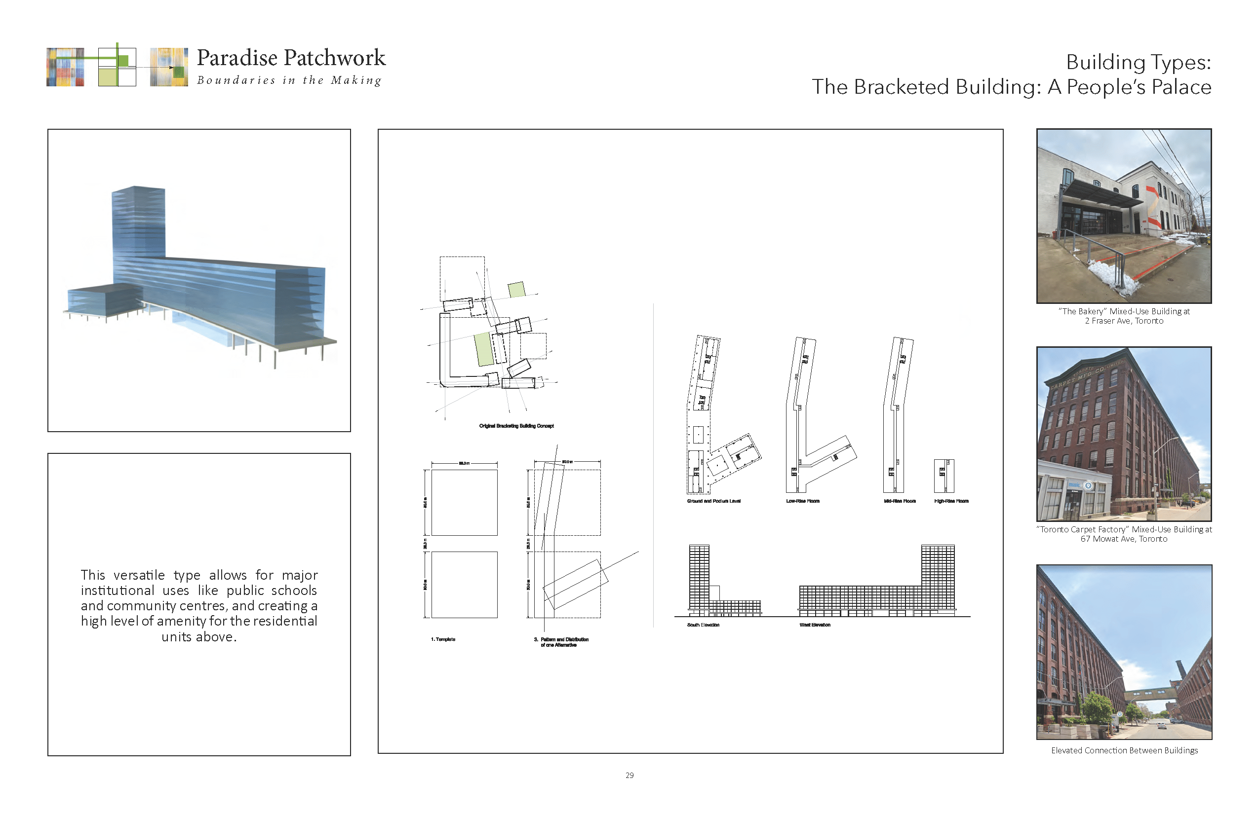
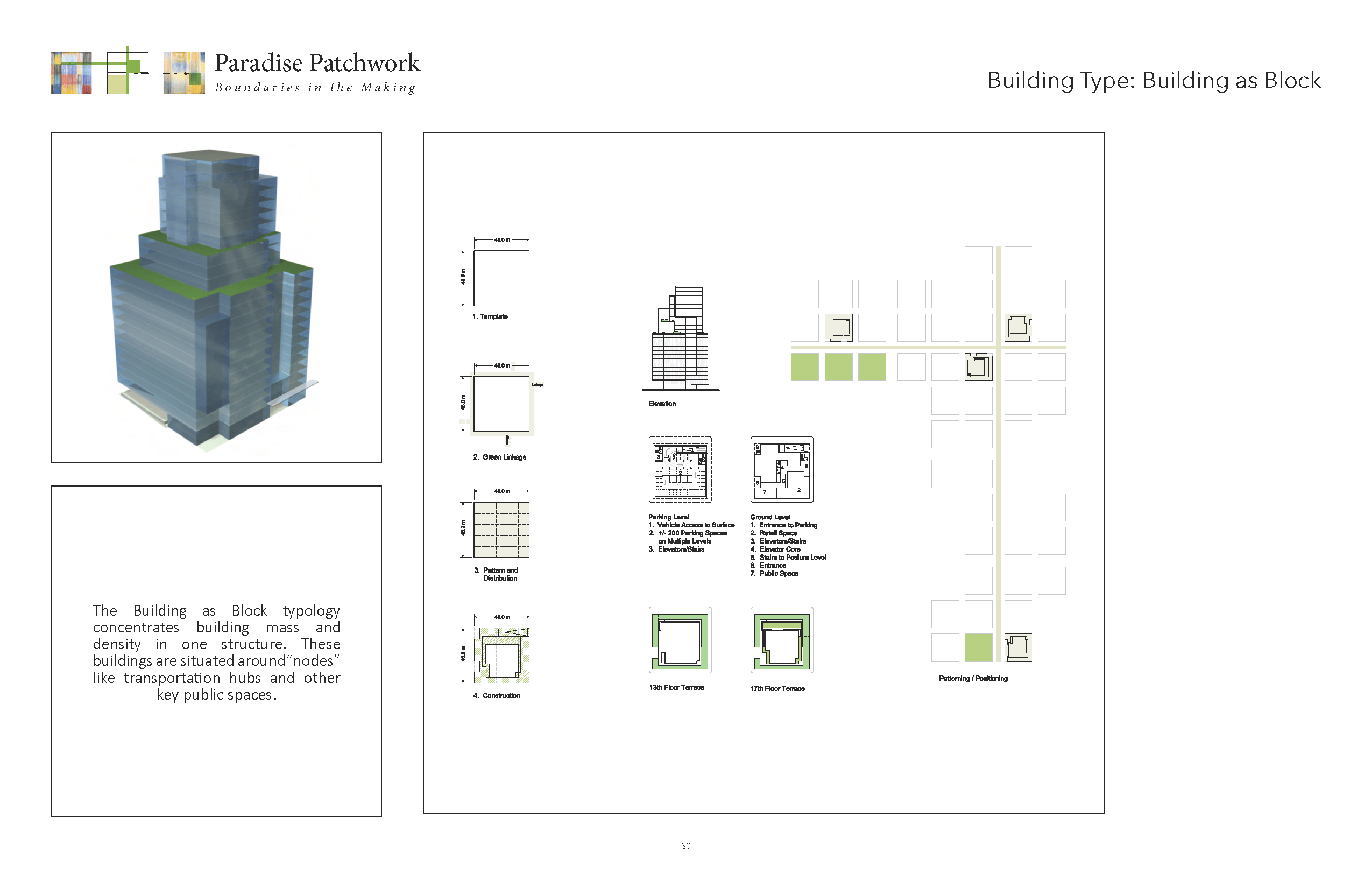
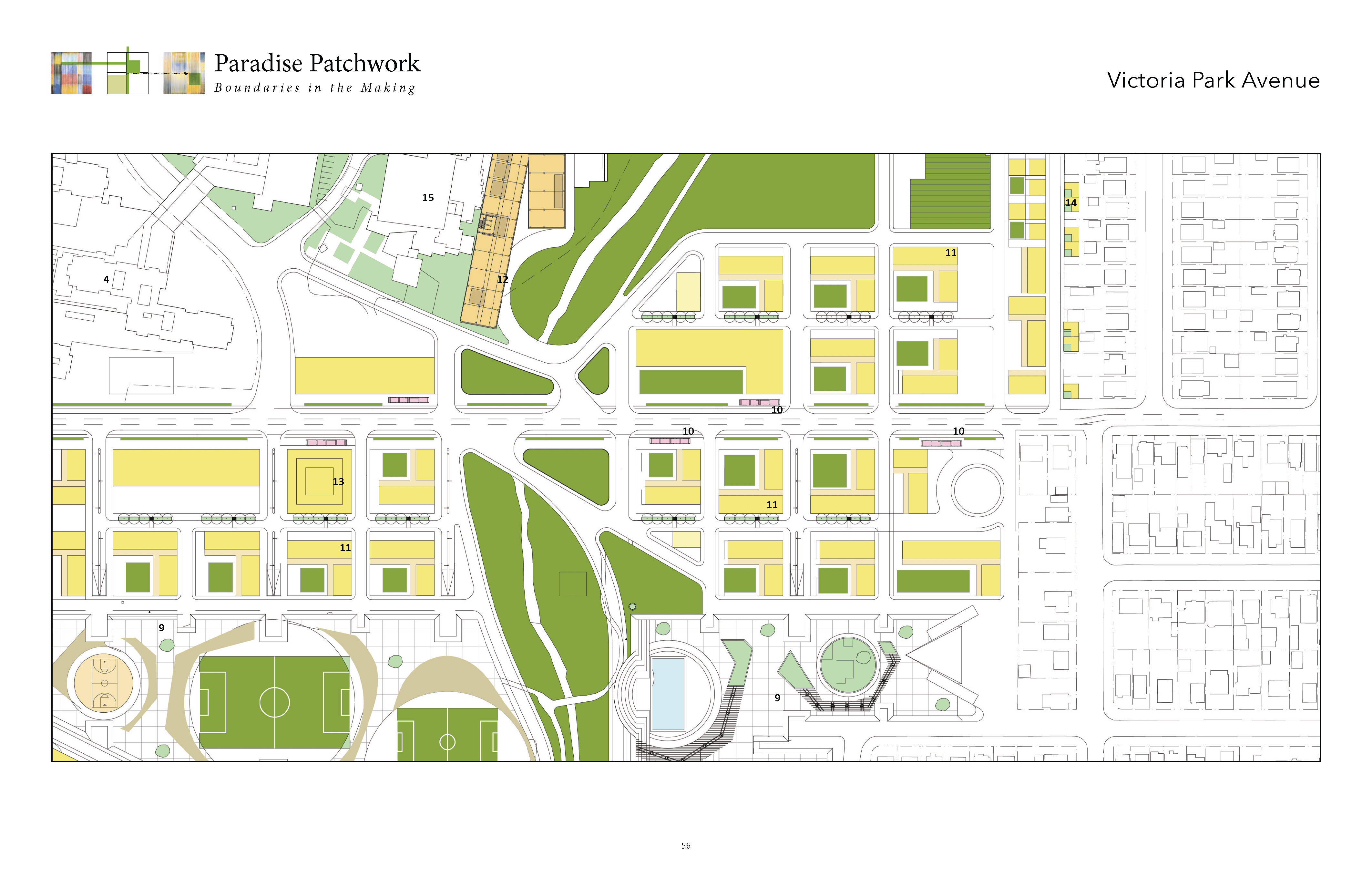
The Bracketed Building: A People’s Palace
The bracketed building is a large-scale urban building whose primary function is to create a continuous linkage and physical edge to the northern edge of Crescent Town and Taylor Creek Park, and to provide a pedestrian linkage between Dawes Road and Victoria Park Avenue. It’s a neutral yet provocative structure open to many diverse functions and future potentials, planned and unplanned.
The linear base of the bracketed building contacts both Dawes Road and Victoria Park, framing and completing the on-the-ground open spaces of Crescent Town. Located on the eight-storey base of the building are four towers that complement and align with the existing adjacent towers of Crescent Town. One possibility is to utilize four towers—three on alignments with the lower bracketed base and a fourth tower located at the right angle as the bracketed form heads toward Dawes Road.
In section, the bracketed building has a two-storey open base that houses a range of pavilion-like spaces that animate the linear walk and interact at grade with the adjacent courtyards and buildings within Crescent Town. This meshing of new and old program potentials gives a new life to the northern edge of Crescent Town and the adjacent Taylor Creek Park.
At the neighbourhood scale, it becomes a large-scale community facility, an urban hub and an opportunity factory. The seemingly neutral architecture and spatial organization creates a degree of freedom for workspaces, educational facilities and other social institutions. It establishes the neighbourhood at a city scale. It unites Crescent Town and the surrounding major streets with an accessible, large-scale green space of public significance and accessibility.
The third and fourth levels of the bracketed building contain worker spaces that can respond to innovative new businesses and organizations. This space is also shared with the adjacent Crescent Town Elementary School, providing expanded education space that intermixes with small business, non-profits and more. Above, all floors become residential units that have access along the entire length of the bracketed building with access to the roof terrace that initiate the start of the four placed tower locations.
Massey Creek Bridges and Public Commons
The three bridges that emphasize the presence of Massey Creek and their specific locations on the three new streets work as part of a strategy that include a series of community commons that interact with the patchwork quilt. They are necessary and significant infrastructures that support the democratic decentralized organization across the connected neighbourhood.
The larger historical narrative of the former Massey Farm and estate Dentonia form and the various progressional changes across the landscape from found natural landscape to agricultural farms to more recent transformations of large scale high rise slab clusters underline the need to take a much more responsive approach to both cultural and natural systems.
For instance the wide 15 metre commons that forms part of the patchwork series provide a common space that links both to the principle street as well goes into the large greenspace. This common space that belongs to everyone and no one is intended to create a more porous and more open suburban condition between the built components of the larger emerging neighbourhood and as a historical reference it insists that this a space of the commons be re-introduced as a kind of memorial space as well as an active new kind of space that once existed but through the various progressive land uses and buildings transformations was lost and forgotten.
Mixed-Use Buildings + Courtyard Apartments
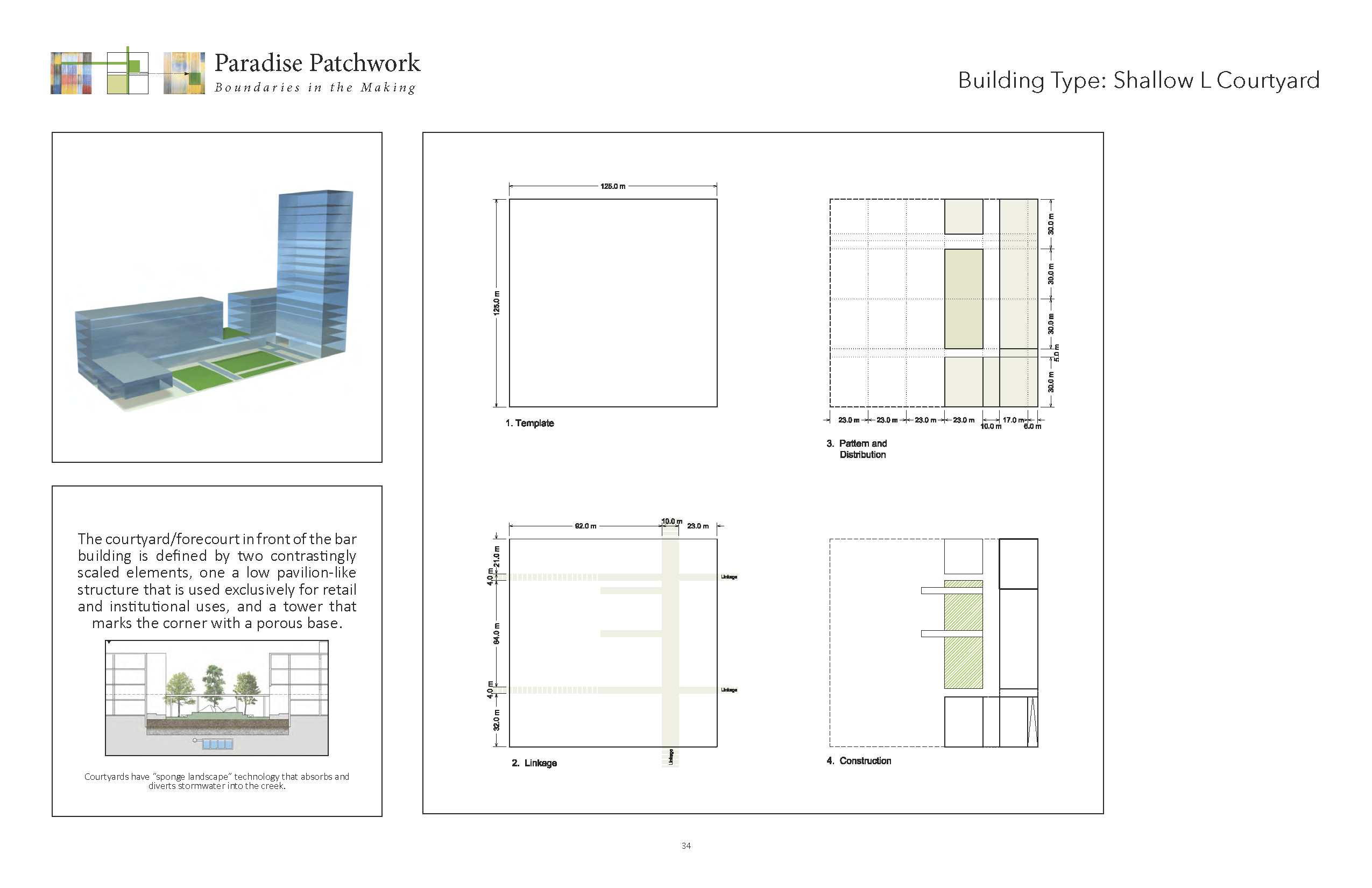
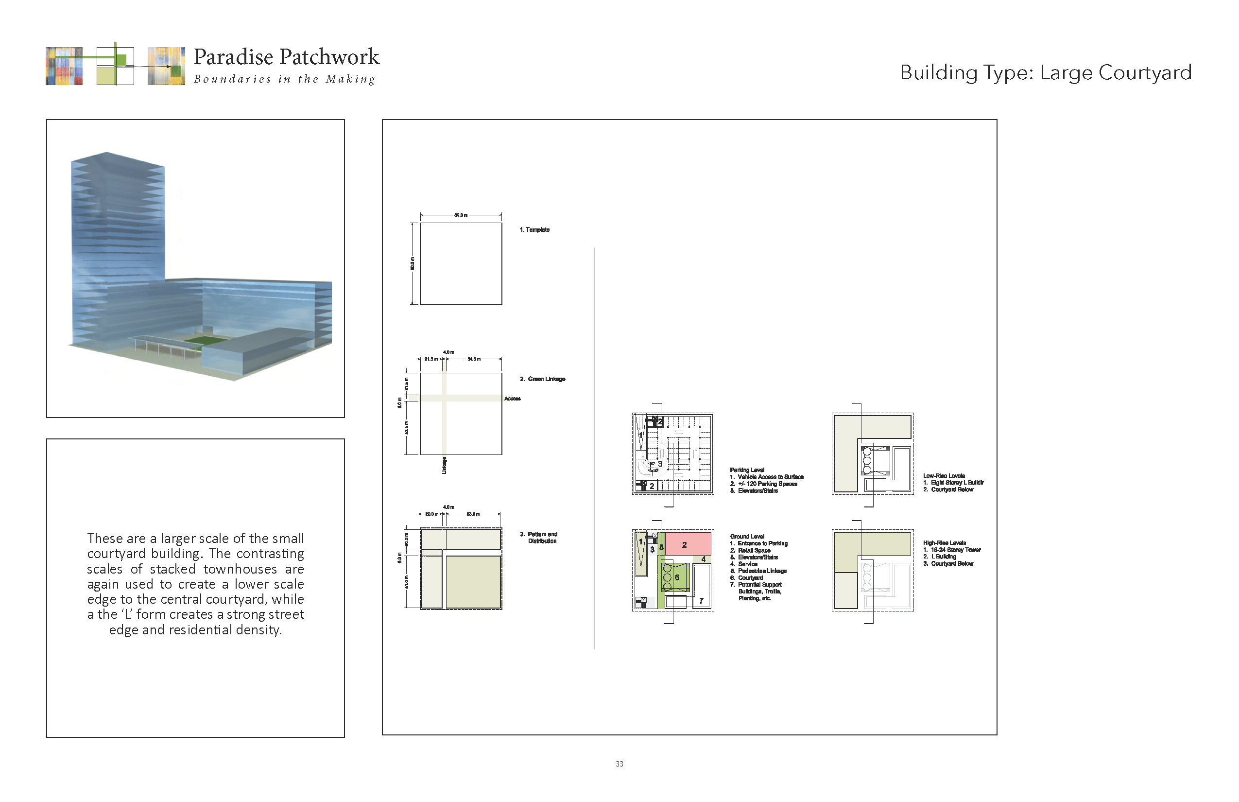
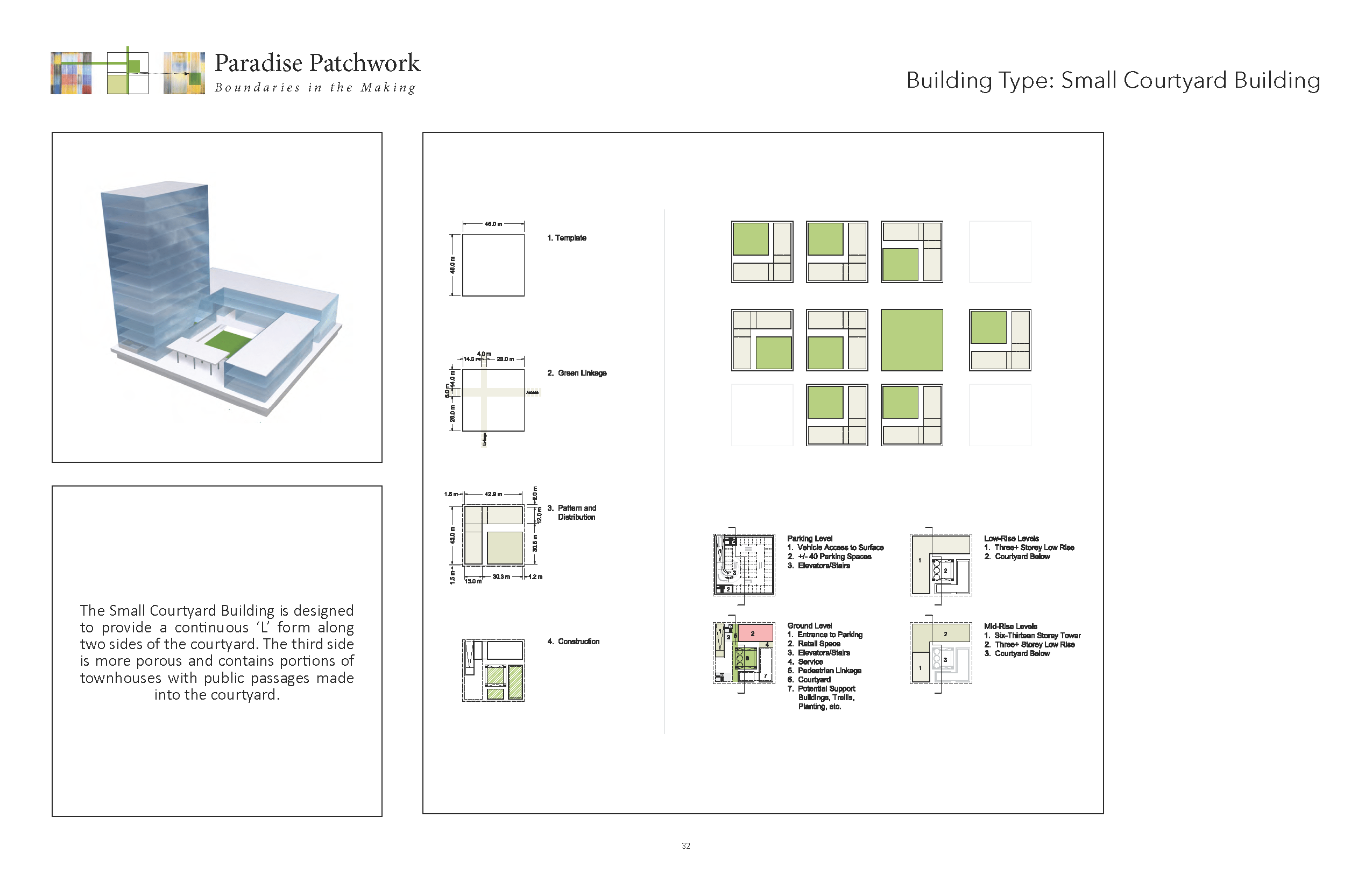
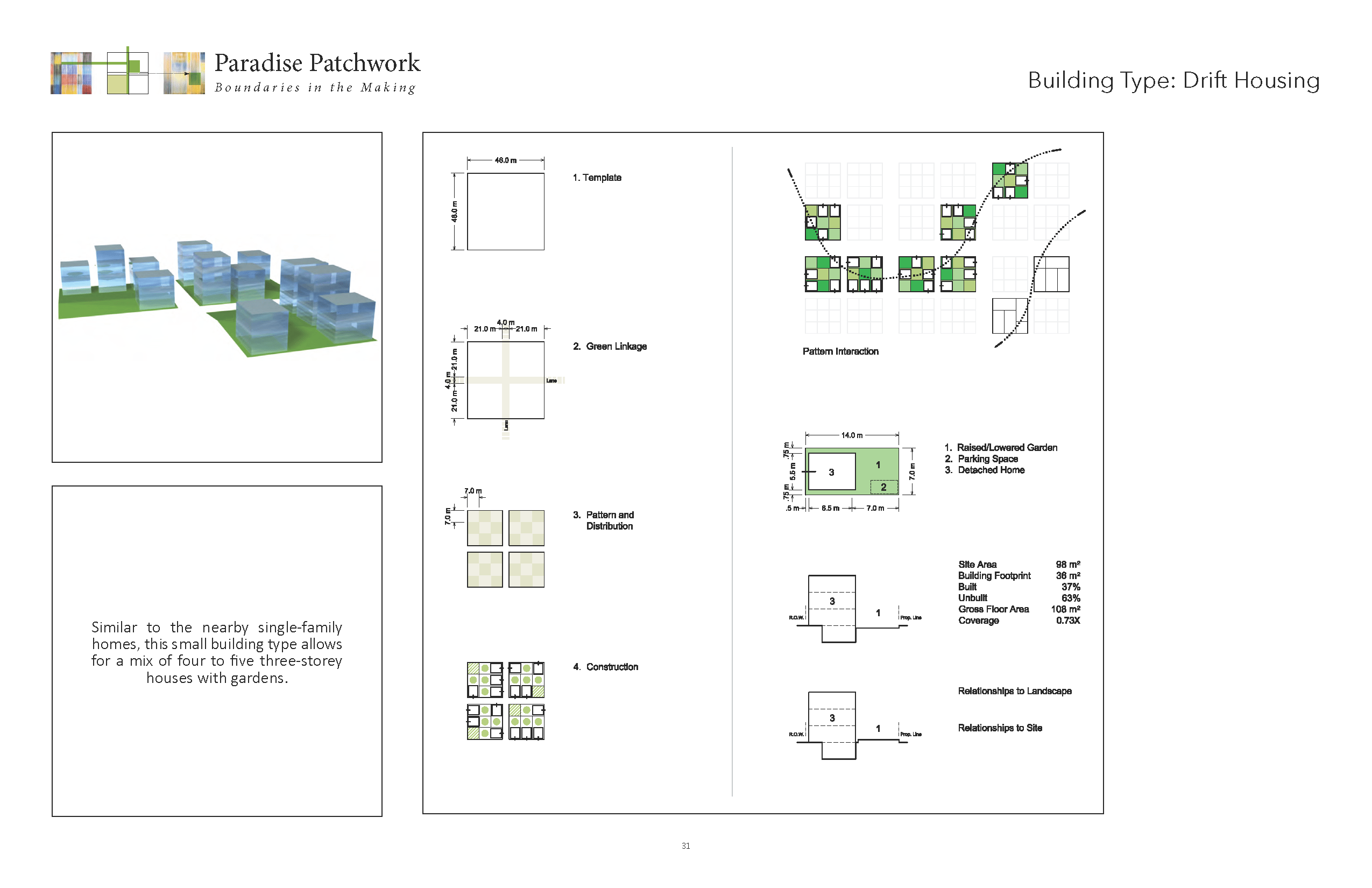
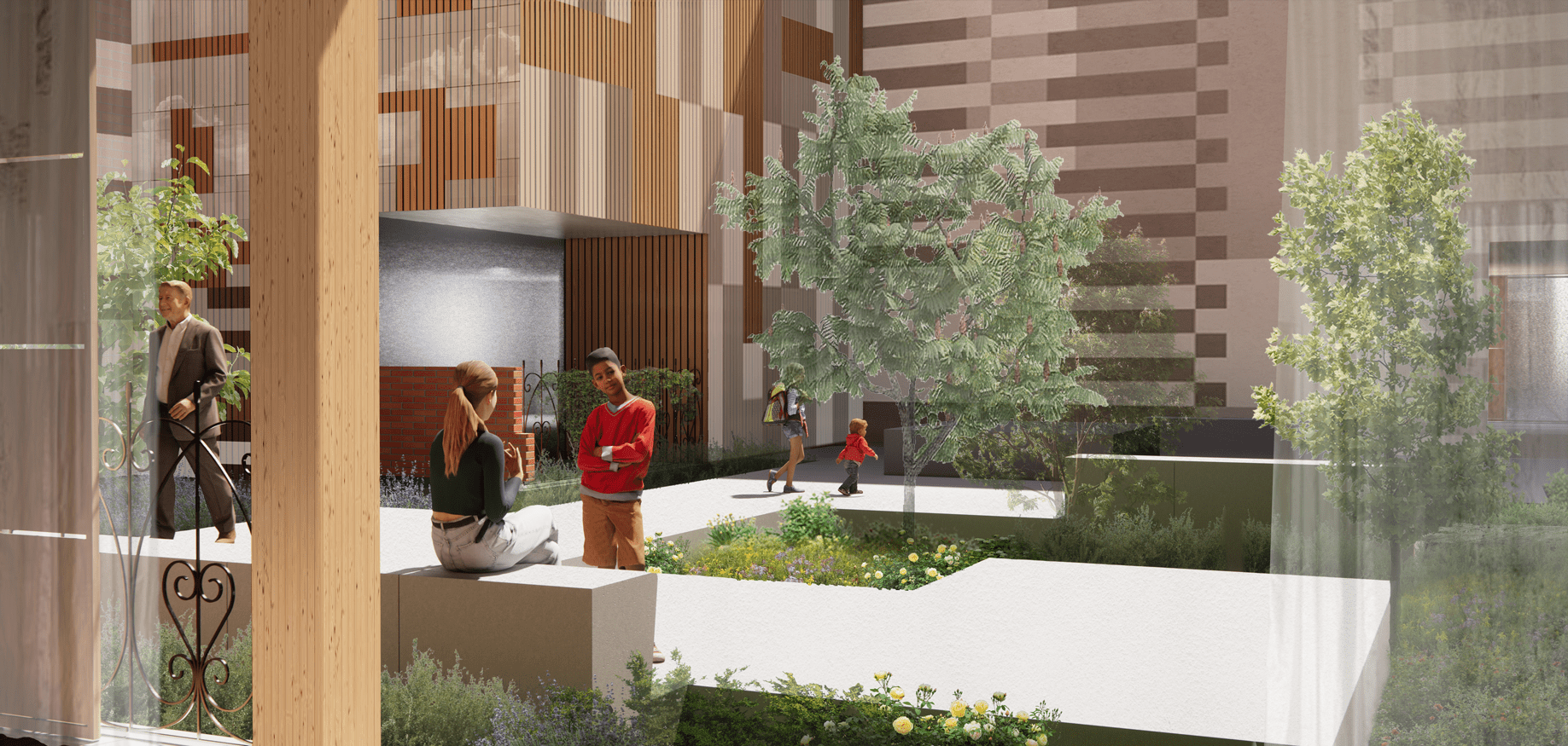
A robust range of building types and sizes provide a variety of mixed-tenure, high-density housing options, with a balance of market-rate and affordable dwellings. Mixed-use buildings also include spaces for grocery stores, healthcare, daycare, and other social institutions. A porous system of new buildings, including L-shaped courtyard buildings, create lively street frontages with a dynamic patterning of interconnected built form and open space.
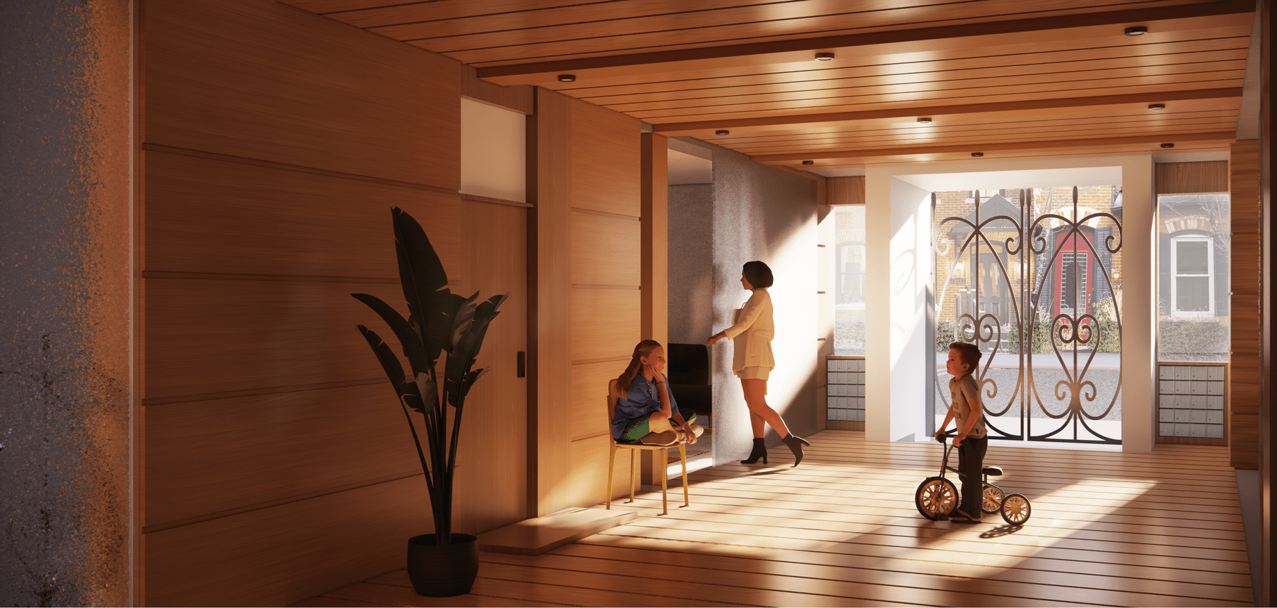
Courtyards provide residents with immediate open space that can accommodate gardens and gathering areas. Porch loggias, where residents access their homes, string units together around the courtyard, providing a common area that is open yet protected from the elements. Rooftops provide another layer of interconnected common space with additional potentials for age-friendly programming. Ten-metre-wide pedestrian streets interconnect courtyards and create an atmosphere conducive to play and active transportation.

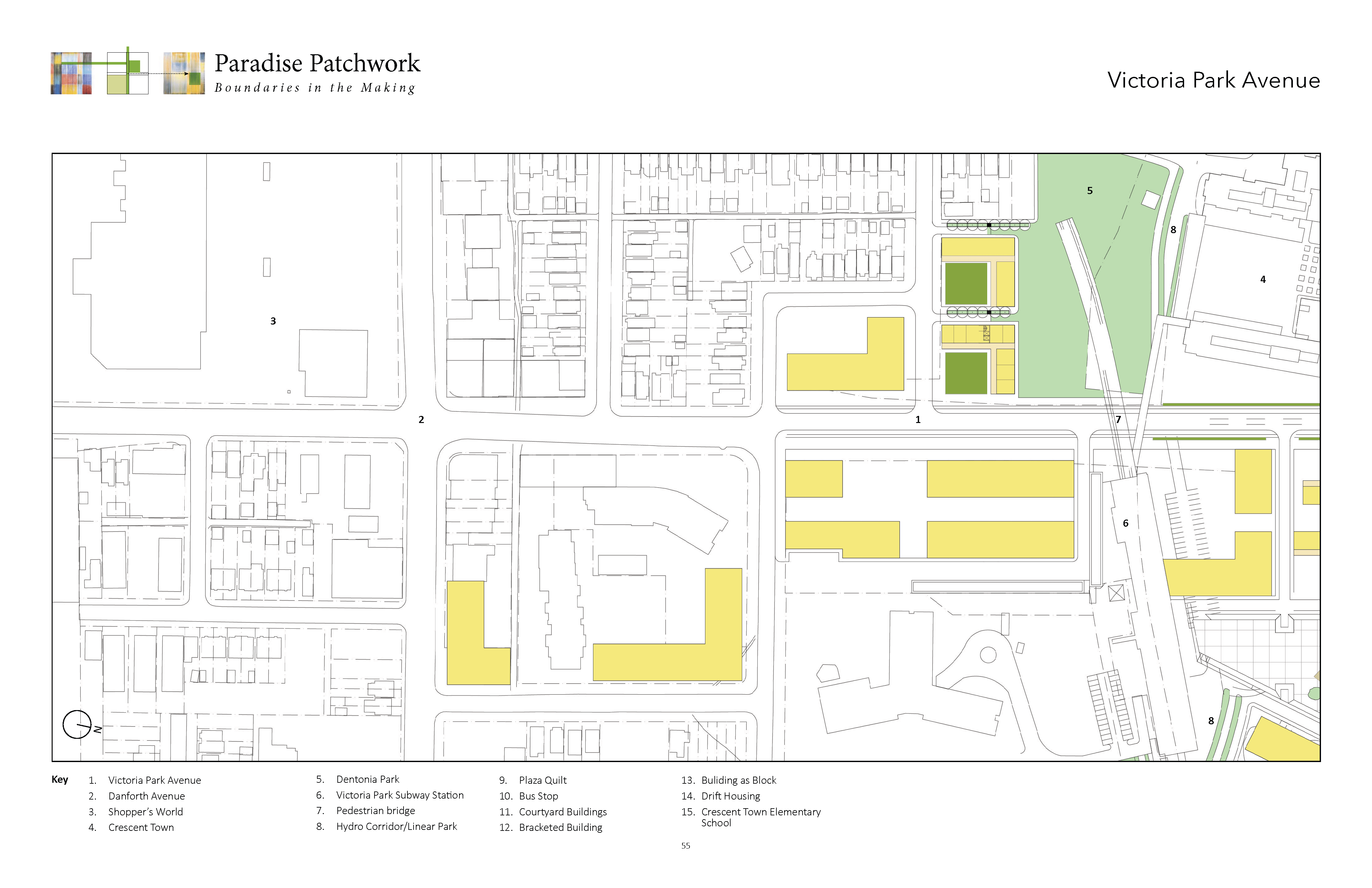
Neighbourhood Beacon

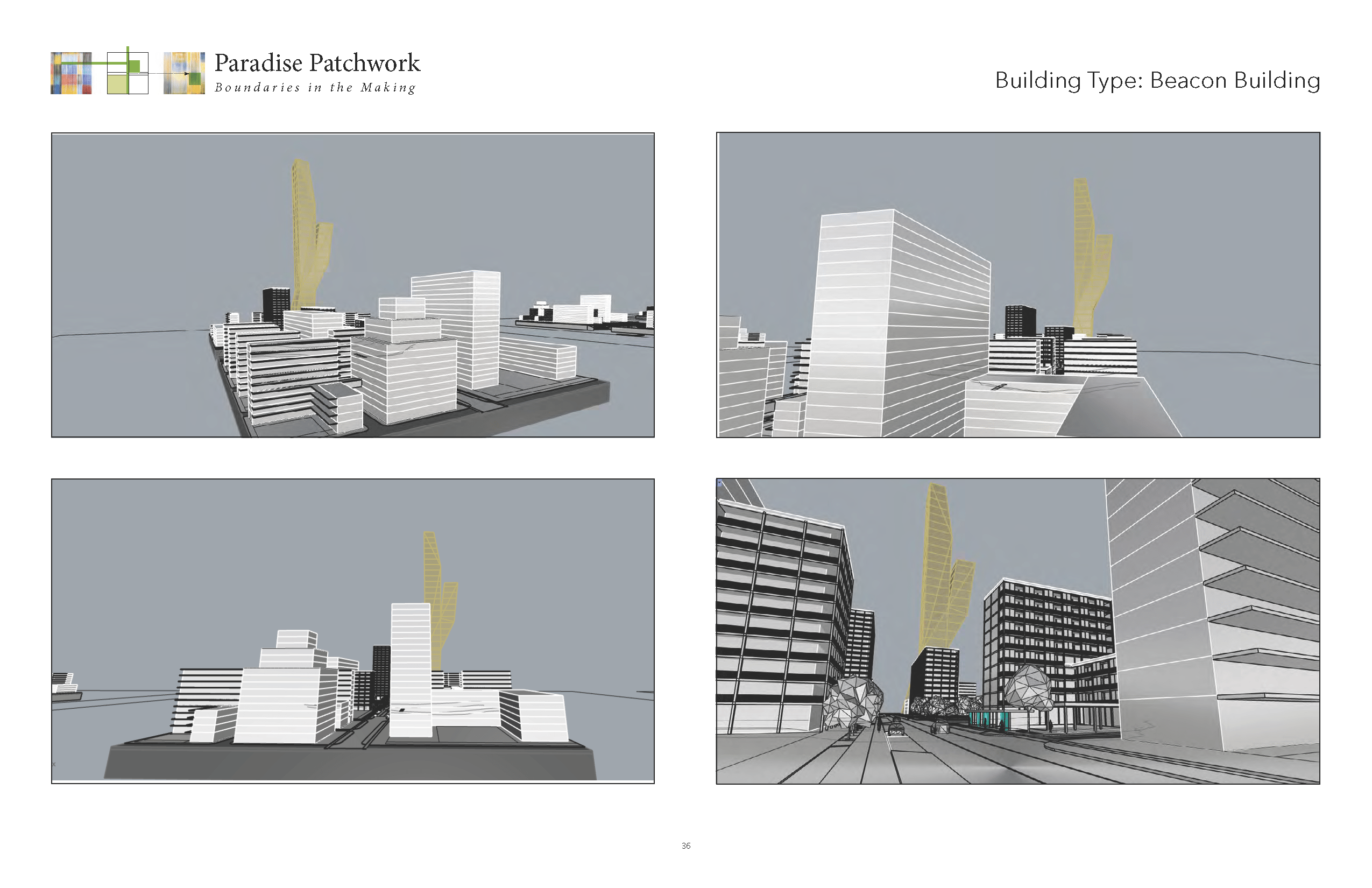
As both tower and beacon this stand-alone building rises up at 88 floors, 264 metres in height. It asserts the new neighbourhood’s presence in the metropolitan skyline. Its unique bifurcated and branch-like structure has metaphorical aspirations that refer to figures such as a large tree, an oak, yet abstract enough to refuse any direct representational fixes. The two upper branching segments of the tower provide and exert a unique silhouette and identity to itself. The various strata levels of the tower beacon can have various floor plates with different functions. The shorter branching structure could contain more green, gardens, in-the-sky terraces in contrast to the other arm’s more straightforward urban-ness.
Viewed from different directions and points of view the tower and its unique configuration changes and seemingly hide aspects of itself. This asymmetry and changing physical orientation interacts with Victoria Park Avenue, along which it occupies a 35×35 metre block. It has unique illumination and media potential at its tops, similar in ways to the Canada Life building on University Avenue. The adjacent bracketed building and the block as beacon are contrasting apparatuses/phenomenon. The bracketed building is mostly long, variegated and horizontal, with carefully positioned towers, while the beacon as black occupies an important point location, and is in the sky as a highly visible vertical building.
The tower’s location/placement on Victoria Park Avenue marks a strategic location that determines an urban hub in conjunction with the long bracketed building, the adjacent bridge and groupings of buildings come together in an intensified group of buildings and open spaces that highlights Victoria Park’s new relationship to the ravine park open space. Much like the evolving and potential changes to the current neighbourhood, the beacon as neighbourhood identifier is a “process in the making.’ The beacon does not have a pre-existing identity to weigh in on but instead is also an “identity in the making” phenomenon. This in turn relies on multiple influences and multiple communities to determine its particular character and meanings, all of which require and depend on a duration and open future.
Victoria Park Subway Station
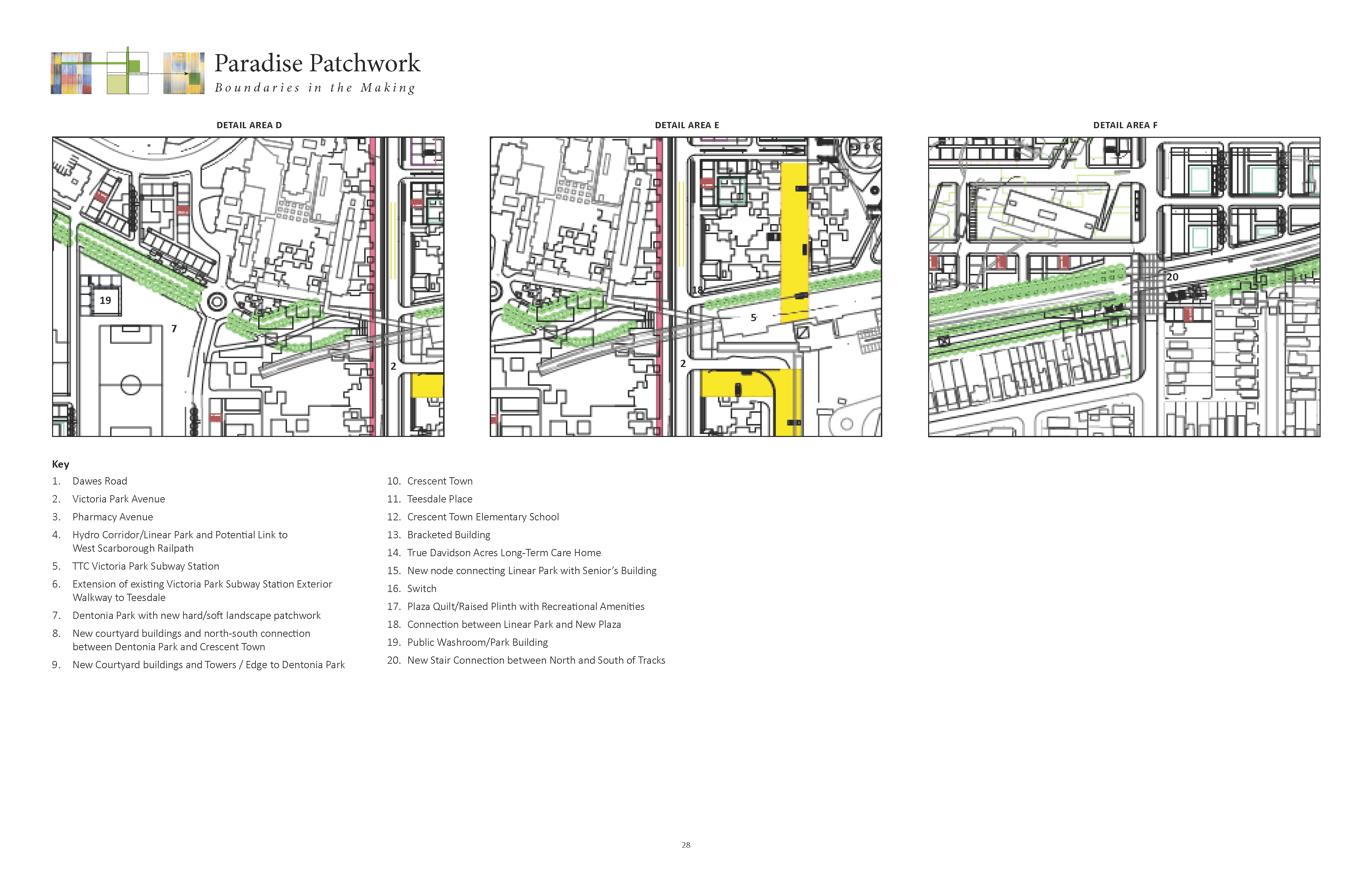
The subway station needs better connectivity around itself. The new housing densities can provide new public space, i.e. a public plaza as a city attraction. The east-west hydro trail connects to the proposed West Scarborough Railpath. The station could also be built on top of itself and given an expanded platform. The partnerships can include new housing and infrastructure improvements to Victoria Park transit plaza. The hydro/linear park encounters a patchwork plaza/transit square and continuation west up the slope between the pedestrian bridge and up to Dentonia Park. This becomes a theme with the patchwork as it changes from a linear passage, or when it encounters an intersecting infrastructure at Victoria Park. It crosses as a road and material pattern, a surface identification with access to the upper walkway connecting it to the transit square.
The new plaza is extended and connects to Victoria Park Avenue, having a wide frontage and as well linkage into the subway station. The subway station provides a bridge and raised walkway access to both Crescent Town and Teesdale, which means the transit is treated as infrastructure and a gap, this is partnering and providing needed amenity. The upper walkway along the northern edge of the subway station has a connection and bridge stair to the transit plaza below, allowing pedestrian crossing from Teesdale and Crescent Town to connect to the transit plaza.
Fine-Grain Infrastructure
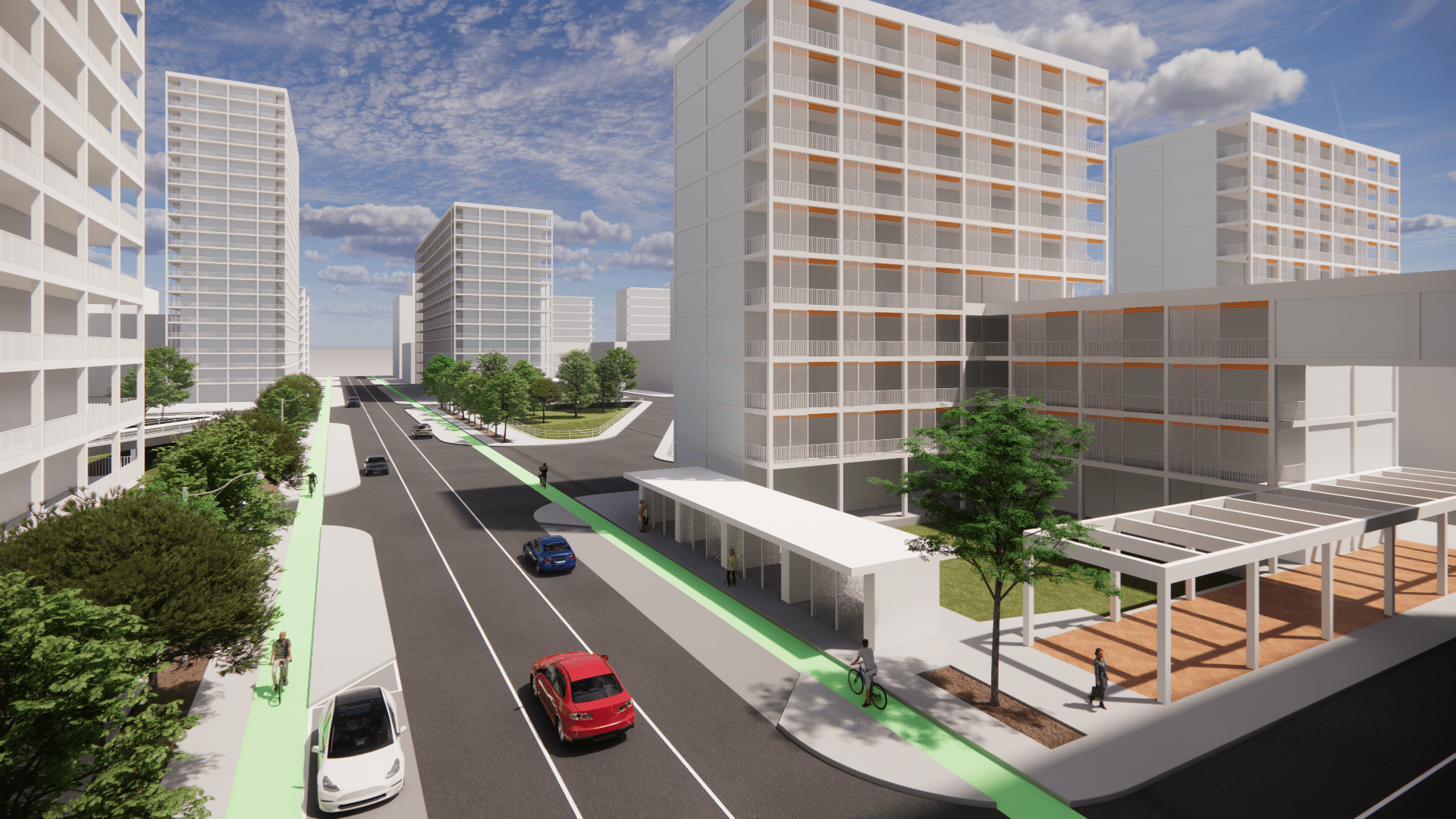
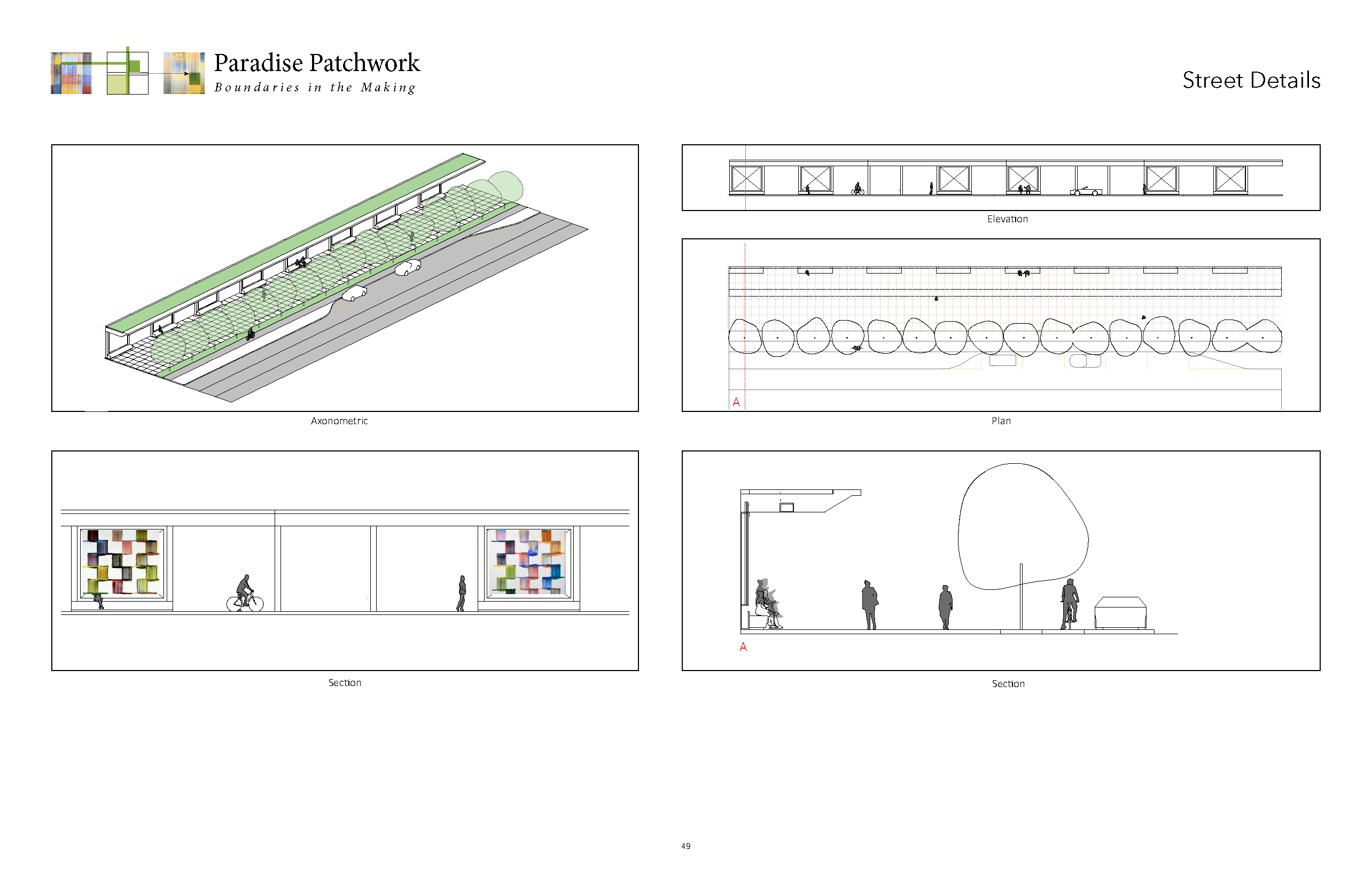
Existing sidewalks on main streets expand to 6.5 metres, increasing space for families and mobility aid users. Additional crosswalks, lines of trees, protected cycling lanes, and larger bus shelters with generous seating improve the experience for residents using active modes of transportation. Each main street is transformed with a new bridge that entangles the existing tower neighbourhoods with the new system of courtyard buildings and pedestrian streets. The bridges showcase the natural landscape, with highly visible and accessible entrances to Taylor Creek Park.
Street Views
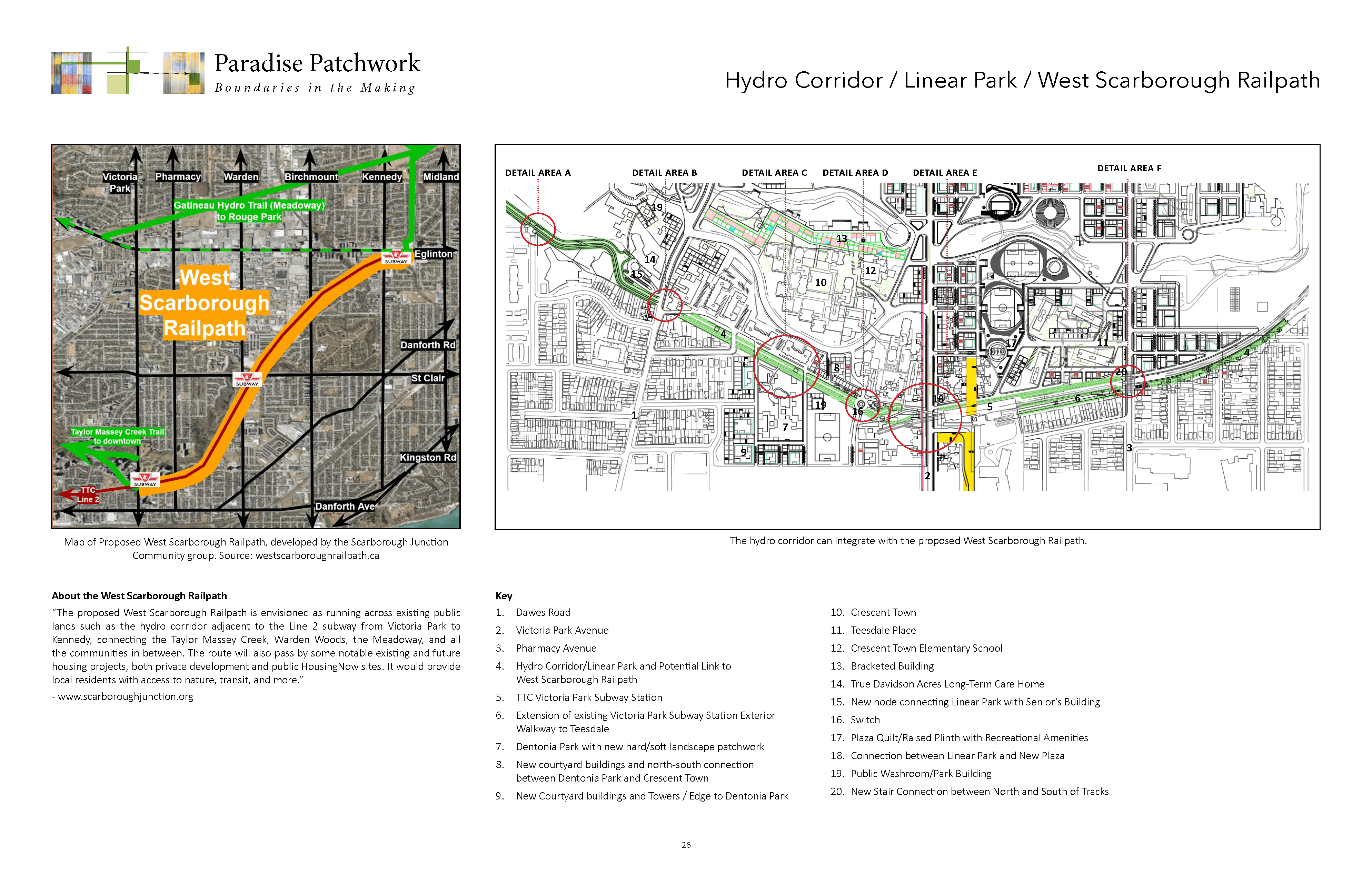
Connecting to the West Scarborough Railpath
The Linear Park and Pollinator Garden: The braided pathway and new developments through existing neighbourhoods
The hydro corridor space is utilized for a city scaled connection. Most importantly, many opportunities along its length find areas for new residential densities. An urban natural symbiosis in which the hydro corridor/braided pathway pollinator garden becomes a porous kind of infrastructure, as a catalyst not unlike the West Toronto Railpath. It reactivates potentials and attempts to undo the separation and autonomous building locations that characterizes many city neighbourhoods.
The opportunity to build new boundaries, even in some park areas, is intended to break down the opposing scales of building that exist between tower neighbourhoods and residential single family blocks and streets. The neighbourhoods that cross between Victoria Park, Pharmacy and Dawes Road have never been able to adjust or build a proper edge to the park/ravine. The fragmented consequences of this have many urban problems, of proper facing building frontages, unfinished blocks, and discontinuous streets. Where possible, a new distribution of towers and lower height garden courtyard typologies are inserted in these particular locations as a meaningful gesture to oppose the marked and isolated separation that exists within this urban fabric and its intersection of parks street with the larger ravine/parkland. What benefits result are the result of open courtyard typologies, courtyards, open to public parks with the ensuing community social interplay between.
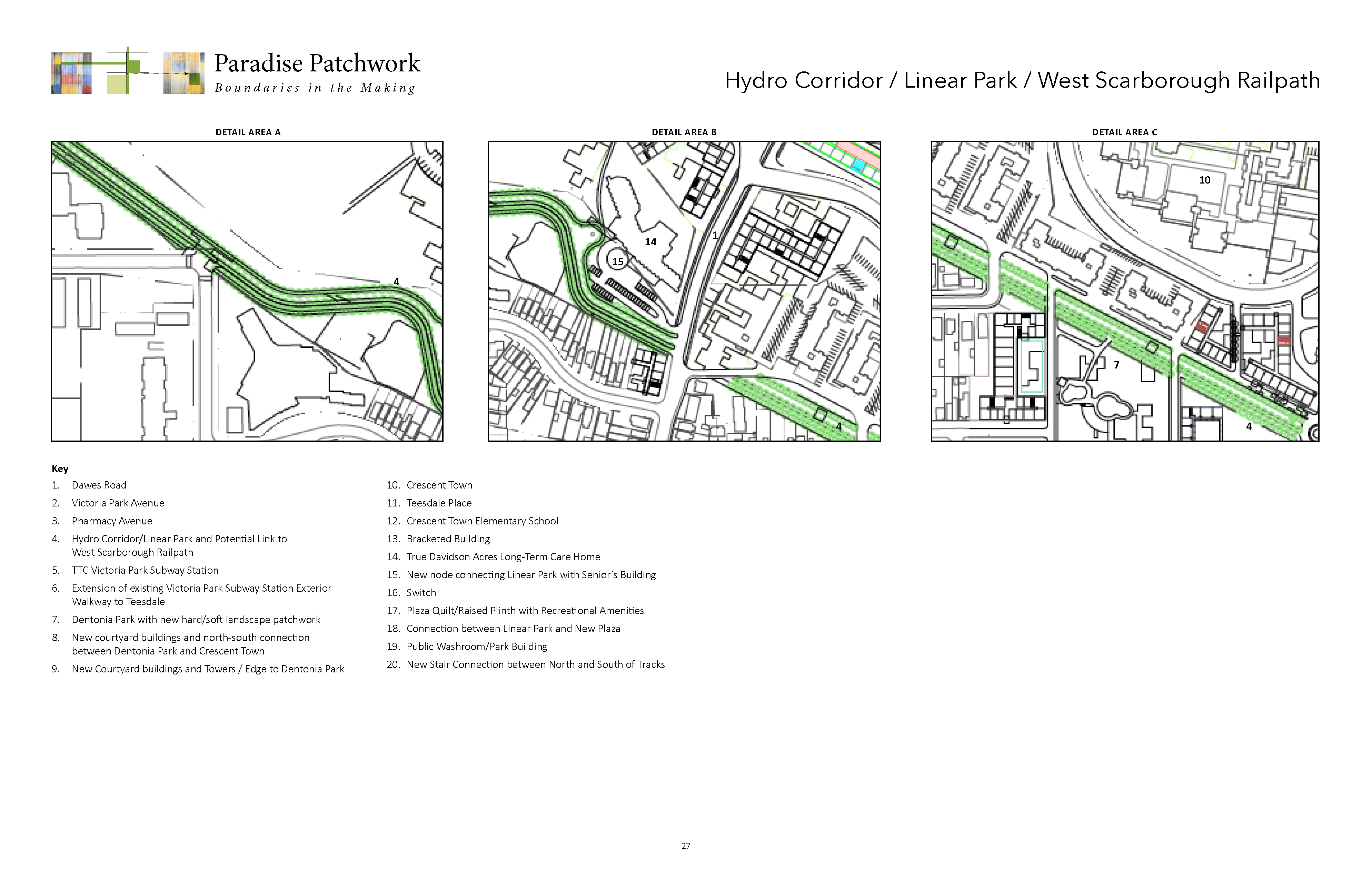
The linear park has a city scale significance and is expandable both to the east and to the west across the city. The entire stretch of the linear park extends to the east of Pharmacy and to the West of Dawes Road. The linear park is divided into three zones: the east, the central, and the western zones. The central zone between Dawes Road and Victoria Park utilizes the central space of the hydro corridor right-of-way. This zone crosses north of Dentonia Park and the southern edge of Crescent Town. The hydro corridor is a braided pathway with three lines of trees and two hard surface walkways, one 6-metres wide and the other 4-metres wide.
The braided pathway includes a 9-metre wide pollinator garden. The garden is punctuated at certain points by a linear patchwork of gardens. These gardens interact with pathways and occasional cross streets. A “switch” location punctuates the pathway prior to its entrance into the existing infrastructures with pedestrian bridge that connects to the subway station. This raised section continues eastward as a walkway along the northern edge of the station. The walkway varies in width with the easterly section having a 4-metre-wide hard surface walk and two flanking lines of trees. The pathway when it encounters Pharmacy then steps up and crosses over the existing above grade subway, then it comes down on the southern side of the railway to continue inside the space of the hydro corridor. The Pharmacy connection could also be something that goes down to the street in a set of stairs and crosses to the other street side. South side and again requires a set of public stairs to go back to the alignment of the hydro corridor and then to points eastward.
The switch location resolves a number of intersecting pathways and disperses the pathway and lines of trees into a terraced landscape to meet the edge of Victoria Park and the linear covered arcade below at street level. The deployment of the pattern patchwork within the pollinator garden and park areas, including Dentonia Park, is intentionally designed to break up the large grassed areas into smaller, more democratic patches that lend themselves to a range of users. The patchwork as a range of different shaped surfaces can accommodate tree groupings, naturalization effects, gardens and or just a range of different sized patches that offer up spontaneous and appropriations.
The hydro corridor as a space is fragmented and variable. It carries on top of the hydro pylons electricity and these lines of hydro power require periodic review and maintenance. The trees therefore need to be limited in their growth so they don’t interfere with the lines above. The solution is selecting the right tree species for the job. These tree lines could be fruit orchards that would complement the space set aside for the pollinator gardens. Again the combined lines of trees and pathways that form the linear park are in fact a “braided” system of hard and soft surface areas that allow for a range of range of speeds for walkers, cyclists, families and different ages groups.