
Carlaw-Dundas Quarter Revitalization Study
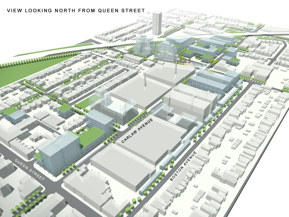
Brown + Storey Architects were commissioned with Rodger Todhunter Associates to produce a Capital Design Strategy for the area around the intersection of Carlaw Avenue and Dundas Street in Toronto. Wedged between more conventional residential neighbourhoods and a historic railway corridor, this former industrial precinct was in the middle of undergoing rapid change, as rising property values were pushing out the artists and artisans who had repurposed the under-used railway-age industrial warehouses and manufacturies. The Capital Works Plan developed through this study proposed a set of investments in public spaces and streetscapes, designed to work together to enhance and accelerate the development of a unique and revitalized urban district in the quarter. The study also proposed a novel built form, modelled after the existing multi-floor warehouses and manufacturies, and built on the example of Rotterdam’s De Boompjes redevelopment, where the multi-storey dock warehouses provided a template for flexible new mixed-use structures.
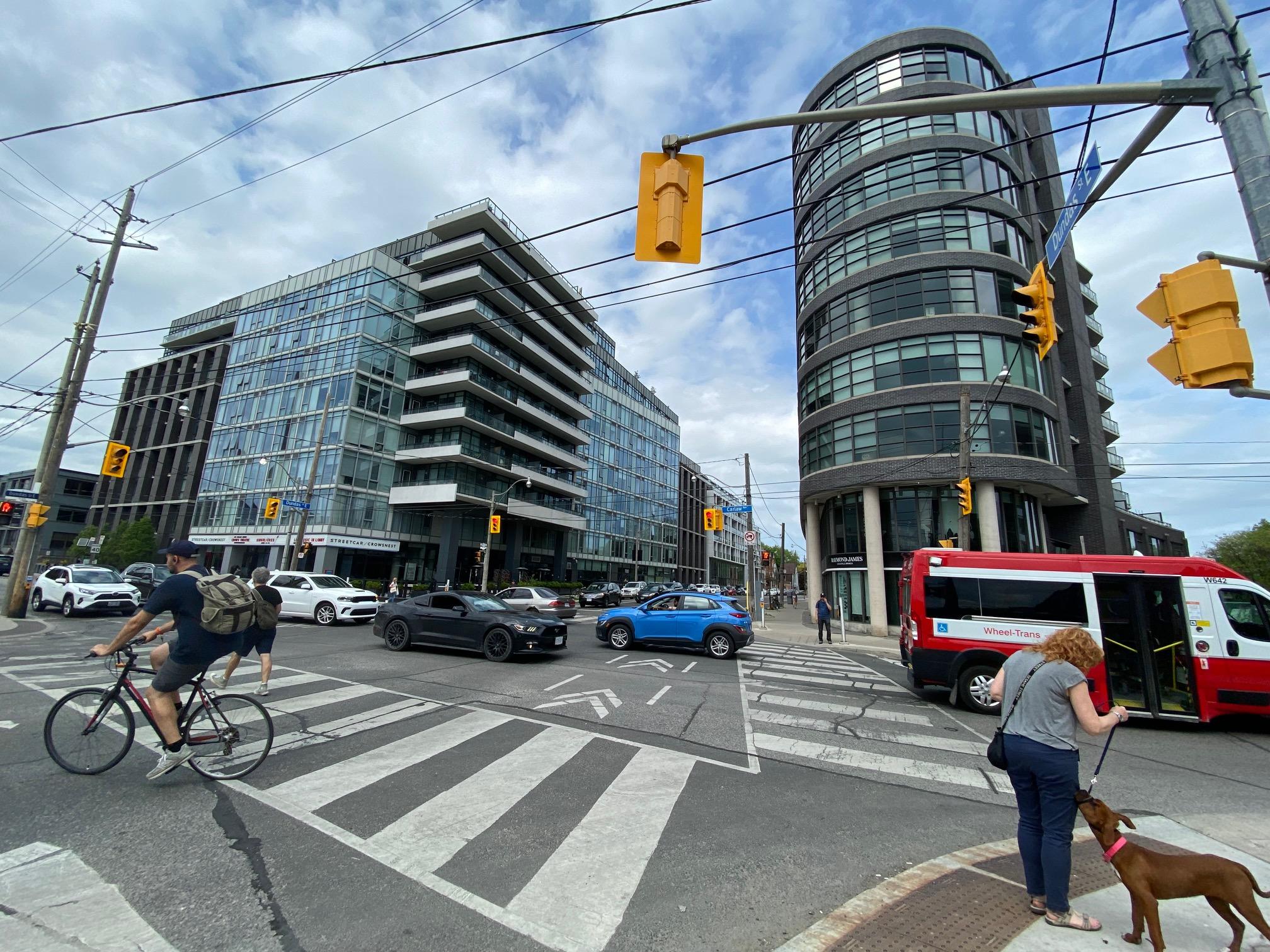
Carlaw-Dundas has seen significant redevelopment since the completion of our study, including substantial new buildings by Streetcar Developments. Improvement of the public spaces of the Quarter, including the seams where it meets the rail corridor to the west/north and the residential neighbourhood to the east, is now being taken up by the city and neighbourhood under the Carlaw + Dundas Community Initiative.
Existing Context
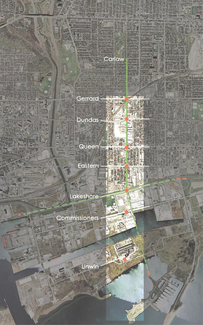
We have given the Carlaw Dundas area the name “Quarter”. The Carlaw Dundas area is unique in its physical form and structure, hence its description as a ‘quarter’ is derived from an area having a strong individual presence that marks it out and contrasts with the surrounding neighbourhood street pattern of single family houses and tree lined streets. As a quarter, it has clear boundaries that are defined by the surrounding streets that include Carlaw Ave, Boston Ave, Gerrard, Dundas and Queen Streets. Added to these boundaries are the adjacent raised railway corridors that create underpasses at Gerrard and Carlaw and again at Logan and Dundas Streets. These infrastructures were once vital linkages to the railway lines supplying spur lines to the adjacent industrial buildings.
New Developments
Carlaw and Dundas form the predominant two streets crossing though the Carlaw Dundas Quarter area and contain the dominant number of industrial fabric buildings. Historically, this industrial fabric provided jobs for the surrounding neighbourhood. Relatively recently, these buildings have been witness to many forms of redevelopment many of which are trying to entice new people to live and move into the area. Live/work studios taking advantage of originally cheaper rents drew many studios and professional groups into the area to take advantage of these spaces. In the context of the larger city these small professional groups support the larger film industry located nearby and in the Port Lands Industrial District.
While most of these transformations were interior changes and to a certain extent invisible changes, there have been recent new developments filling the many voids within the Quarter. New housing and studio apartments are starting to fill in. To date, the public spaces characterized by the surrounding streets and the new developments have not coalesced with the public realm in any comprehensive way. Contributing to this affect of the area is a ‘mean’ quality to the public spaces of the street; narrow sidewalks, cluttered infrastructure, and lacking in improvements. While there are some exemplary buildings to be found on Carlaw Ave., there are also many low scale industrial buildings put up quickly, and built tightly together. This pragmatic nature has had both positive and negative effects for the area.
Taking Responsibility for the Public Realm
Vitally important to the overall identity and image of Carlaw-Dundas is the need to improve the quality of the public realm. The city can do its part to improve the spaces of the public and its streets, but where also might the responsibility lie? It is not enough simply to build and develop a site to maximize densities and heights at the cost of the public realm whose environmental fitness is low. Nor is it enough to architecturally produce the most sophisticated building aesthetically and technically. Although these qualities are desirable, it is imperative that private development contribute to the ‘public spaces’, and create its own environment. Lifting sections of buildings up, creating courtyards and plazas, for instance, creates improvements and reinforces the qualities of the architecture.
The physical environment of the Carlaw-Dundas Quarter is one that has been constructed primarily with buildings that fill their entire site, building a continuous wall to the street. This demarcates the private realm in sharp contrast to the public space of the street. Having their origin as industrial spaces, these structures illustrate a pragmatic straight forwardness indicative of the period of construction in which the interior working production environment took priority over the public realm. Carlaw/Dundas has little or no public spaces. The spaces that do exist cluster themselves along the edges of the infrastructures, passing through the area. Carlaw and Gerrard for example has three park fragments that collectively don’t add up to a system, and in particular, the sidewalks adjacent to these parks simply pass by, rather than taking a more direct role in impacting the public space.
We are proposing that these fragments become more actively engaged in the public realm, connected where possible and that they form part of a larger matrix. In particular, we are proposing that the sidewalks take on a more specific role in inscribing themselves into the parks themselves. This utilization of the sidewalks to penetrate into the park makes them more accessible and safe, reducing the many closed, dead-end conditions in favour of an open circuit of movement and access. The urban design street improvements to Carlaw, Dundas, Boston and Colgate and their complement of new trees will further reinforce the connectivity of these revitalized park fragments and include them into a larger collective organization of spaces with a corresponding benefit to the over all Carlaw Dundas Quarter.
Capital Improvement Initiatives
The Zone: A Complementary Meeting Place
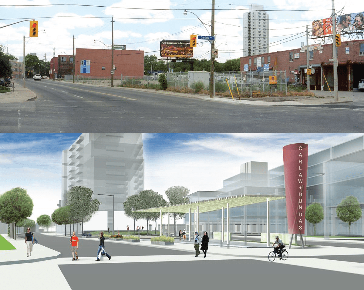
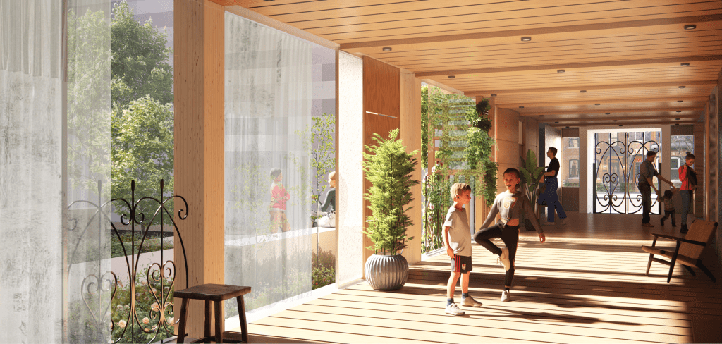
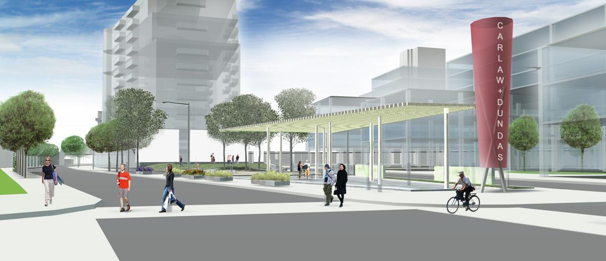
The intersection of Carlaw Ave. and Dundas St. is a place where a vital public space can be created. A narrative of urban, economic, and social change could find expression here. This unique surface could include a gallery and stage in which work can be presented, and performances realized. It is a space that is livable, open, and inhabitable in more than one interpretation. “Zone” could be a physical and conceptual space, rather than a place that is overly determined by specific restrictions or types of construction. For example, this space could present itself in a unique way with very expressive materials. It could have a wooden deck, interspersed trees, event lighting, adjacent amenities, a café, and supporting businesses. Here “zone” could be an emblem and branding for an area of the city that is the exception to zoning.
The discontinuous street, the unique breaks and brief perspectives created from the space between buildings, interior courtyard and short streets, are exceptional encounters unique to the Carlaw area. The framing of these spaces allows them to evolve their own particular potentials – reframed without being overly determined. A strategy of framing the informal structure of the Carlaw-Dundas area exposes its special elements in a unique way. For example, the traditional line of trees on both sides of the street do not frame, but in fact constrain the adjacent building to the limited space of the adjacent sidewalk. A more effective strategy is to allow the frame to be surpassed by what it is trying to contain. This strategy discounts the traditional continuous line of trees in favour of segments, that allow the space of the framed segments to be extended and be open-ended.
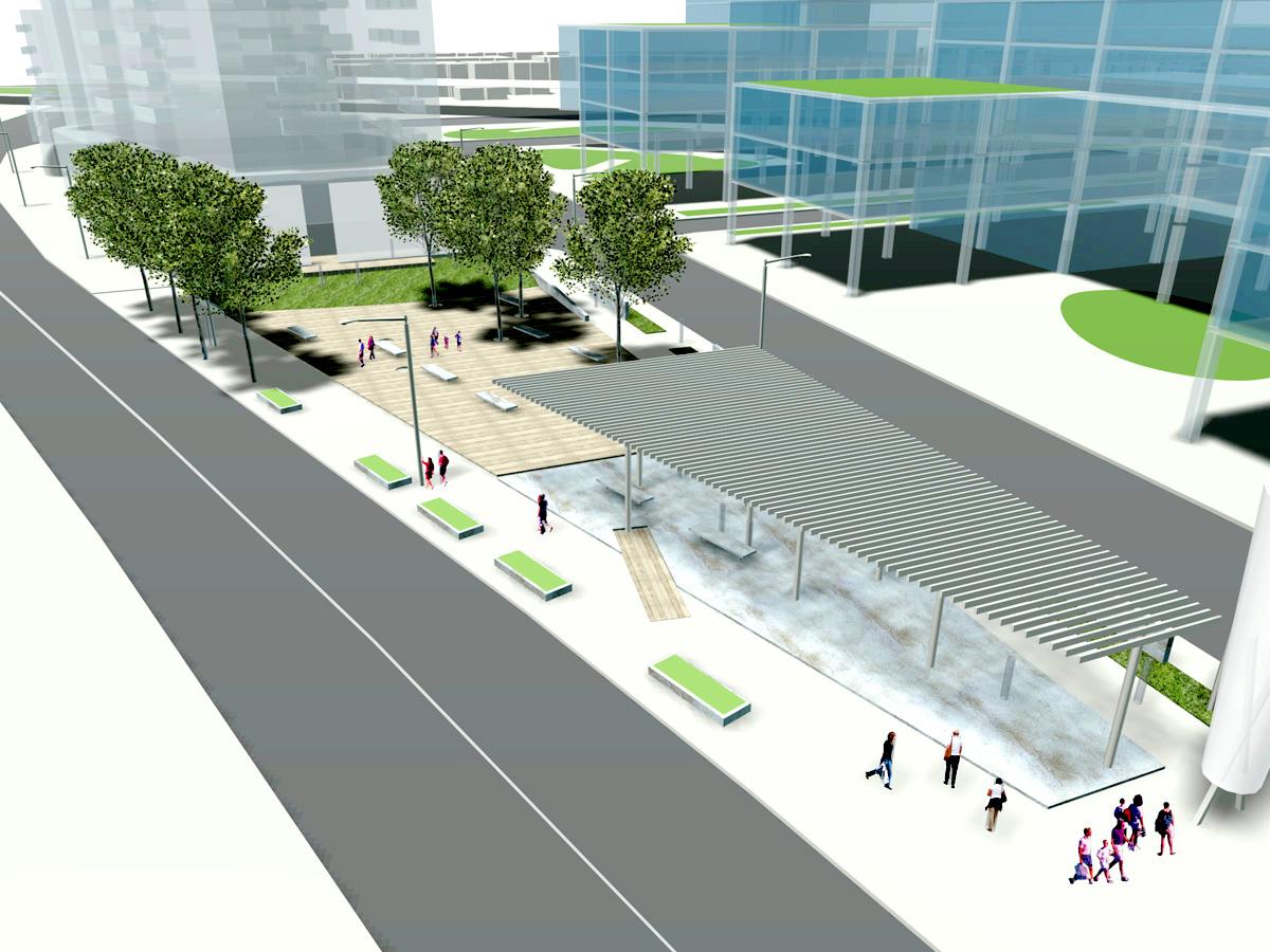
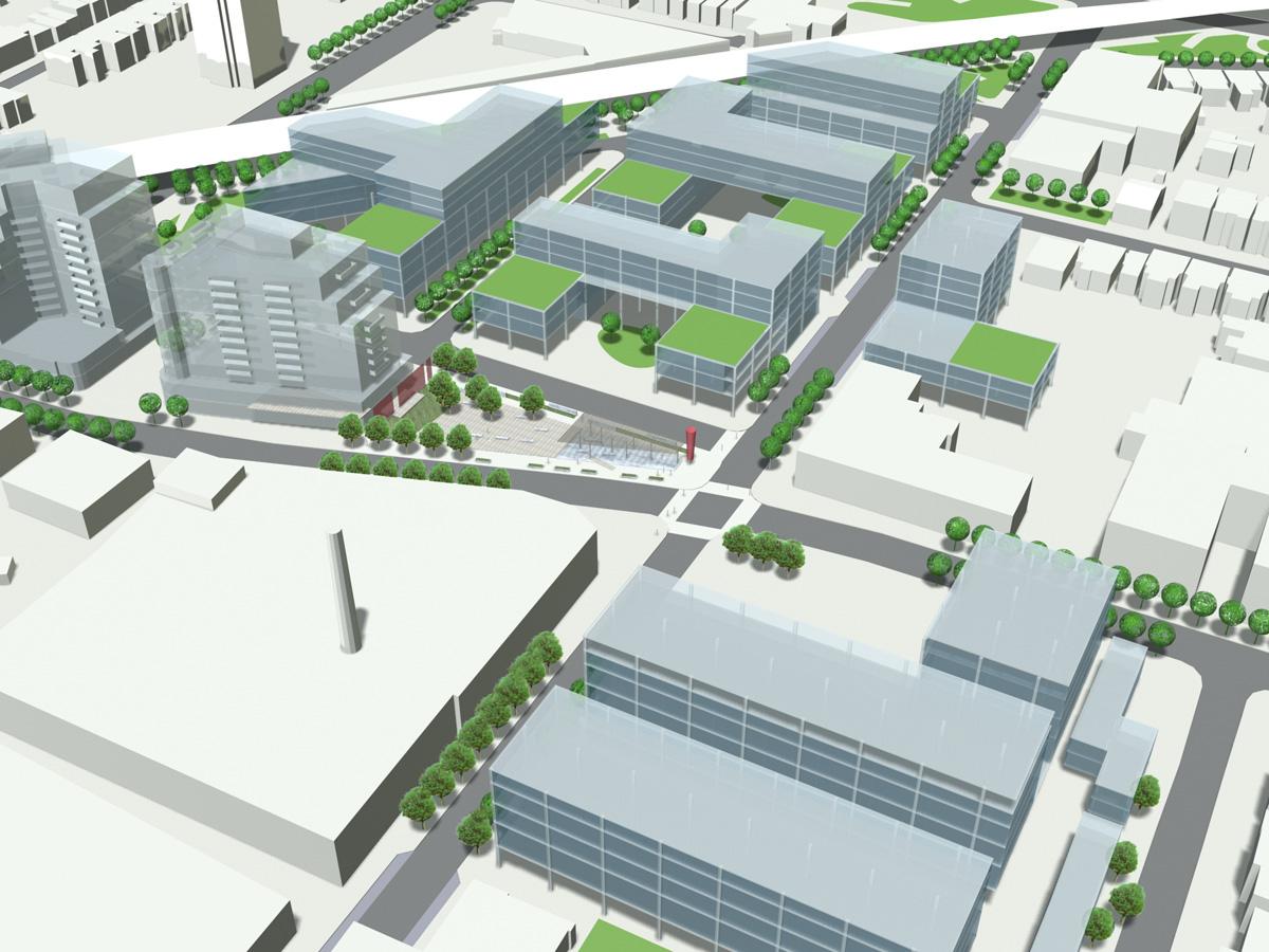
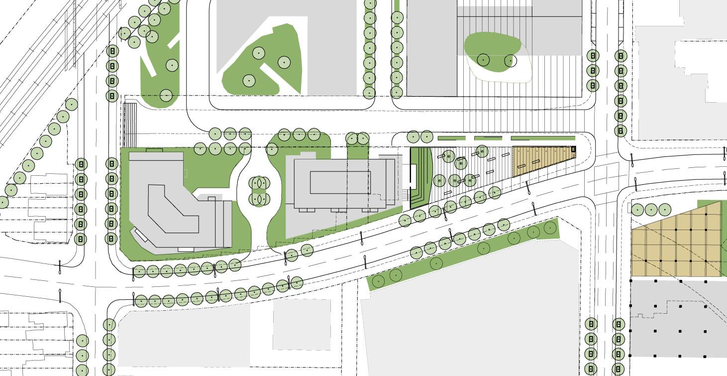
The 1,000-square metre site available for a public space is of strategic importance in getting started towards a new image for the area. As a space, it needs to be programmed and understood in
relationship to the needs of the adjacent developments, professionals, business, and neighbours. On its own, the space is not large, but connects to at least 6 adjacent developments and owners. 401 Logan, its westerly neighbouring site, offers a good opportunity to connect it with a new building and future users.
Zone Section 1
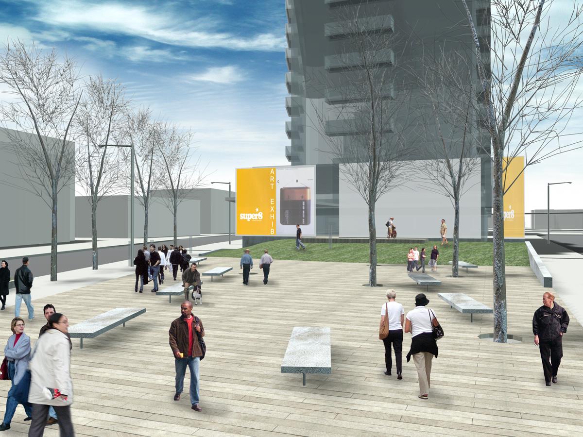
The visual axis of Carlaw when looking west culminates into the ‘zone’ – here trees will extend the alignment, and create an informal focus at the terminus of the site’s western edge, partly enclosed by 401 Logan and a green treed effect. The zone is a small, hybrid, triangular space, partially divided into three types of spaces. The first zone nearest Carlaw is a hard stone surface area with a raised wooden trellis and signage lighting feature, that acts both as a symbol for the new quarter, and also as a transition and corner. It intentionally leaves it relatively open, but also to suggest an informal structure to it as a support.
Zone Section 2
The second or middle space of the triangular plaza, being the widest part of the triangle, extends the line of trees east of the site and combines with the adjacent street trees proposed along Dundas Street to create a ‘thicker’ double layer of trees. This surface, in contrast to the first zone, is wood in nature, and is patterned to reinforce a larger-scale unit, and reflects a boardwalk image, scattered informal trees further the thickening aspect of this space, providing contrasting sites for shade and sunlight.
Zone Section 3
Further west, the final zone of the space consists of a vertical wood event wall intended to create a series of portals and edges for the open space, while at the same time, providing space for commercial and community signage. It sits in a green, grass surface, suggesting a protected garden space. Bench seating within the boardwalk provides an ample number of spots to casually enjoy the unique qualities of the plaza.
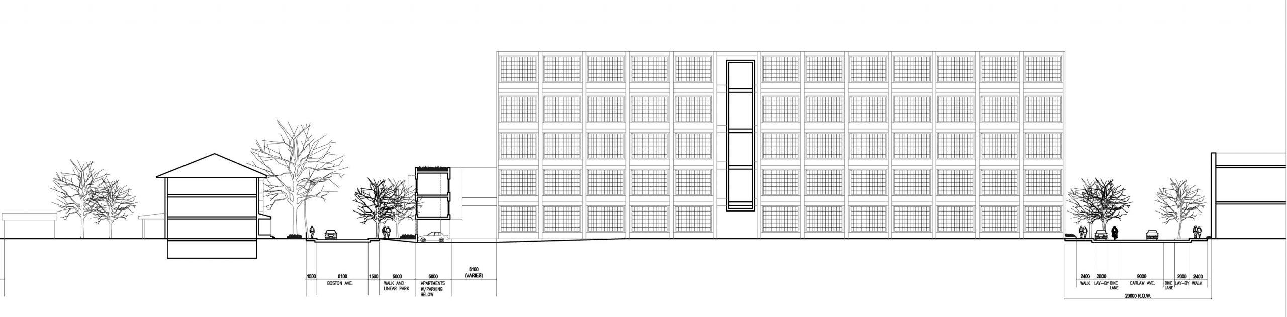
Carlaw Avenue
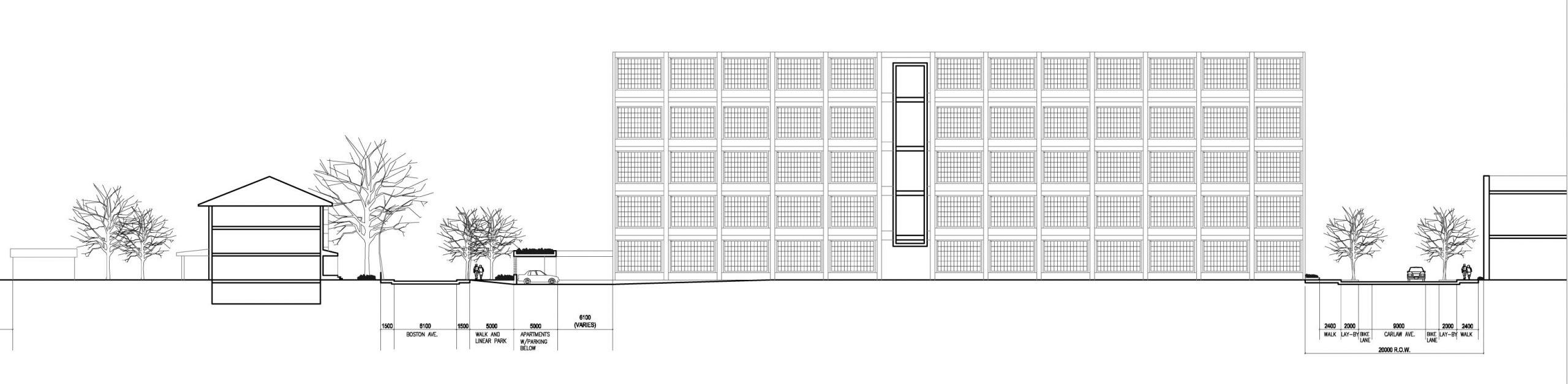
The physical appearance of Carlaw is one in which narrow sidewalks, deteriorating road beds, proliferating cedar power lines, and scattered trees prevail. There are scant breaks from this ‘non-atmosphere’ of the street. What further aggravates this hostile condition is the lack of parks or open spaces in the neighbourhood. There is no coherent urban design and it is conspicuous in its absence. The street right of way is 20.0 metres and because of its former industrial character, was simply seen in a utilitarian way – industrial buildings lining both sides of the street. The overall image is of a narrow street with lots of parking and cluttered utilities.
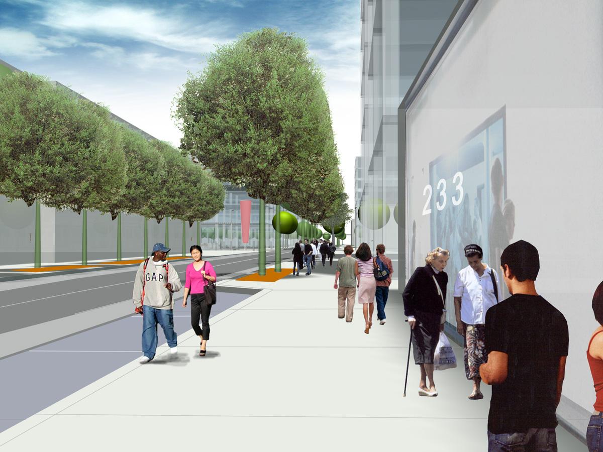
To improve this condition and create a unique support and identity to match the current transformation going on requires a large-scale plan. We are proposing a road narrowing, with a corresponding widening of the pedestrian realm. To further improve the street, we are suggesting a unique tree planting and lay-by parking strategy. By using segments of trees grouped and symmetrically located on both sides of the street, we are suggesting an alternating rhythm of trees, which create open frames to showcase the existing buildings and new buildings along the street. This idea is in contrast to continuous tree planting on both sides of the street, which we believe separates the sides of the street from each other.
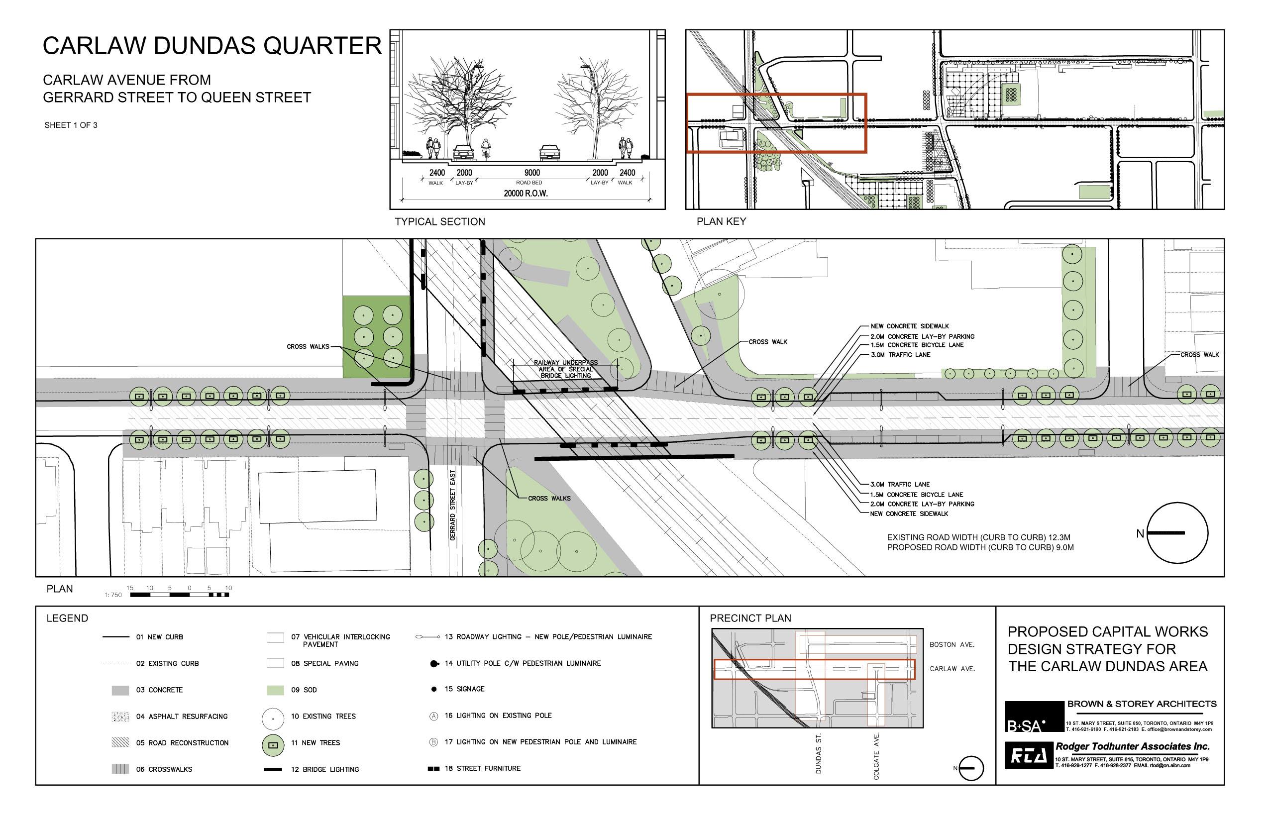
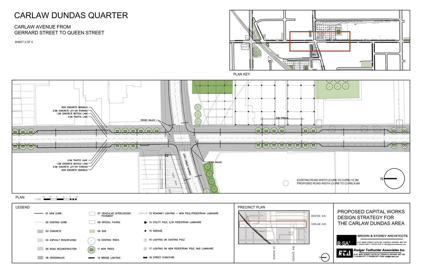
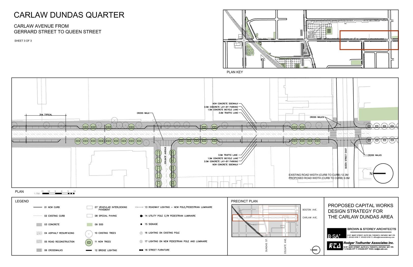
Segments of tree groupings of 8 to 10 trees alternate with balances and symmetrical parking lay-by’s. These lay-by’s are distributed along the street to take advantage of the best position for parking that maintains and protects lane access, corners and in turn, where the lay-by’s do not exist, create wider sidewalk conditions and better conditions for tree planting. Two lanes of traffic are maintained along with bicycle lanes.
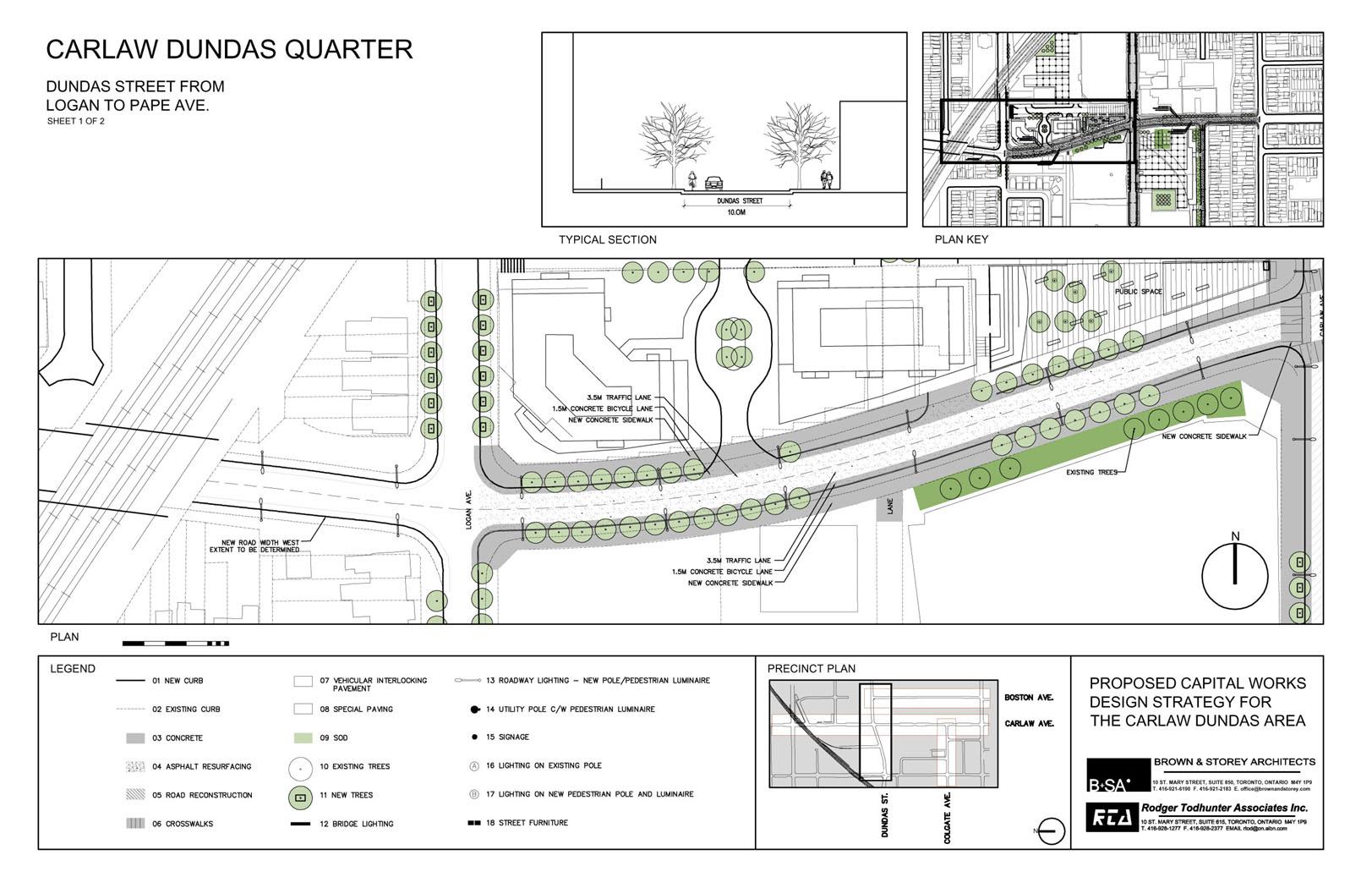
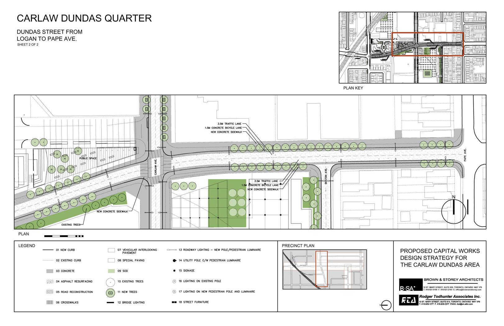
Dundas Street
The current road and cycling improvements, mostly the result of road markings, has left a ‘surplus’ space in the middle of the road. We are proposing a total rethinking of Dundas into a configuration that maintains the current reduced car lanes and bicycle infrastructure into a slimmer curb-to-curb street, effectively adding needed space to the pedestrian realm, with wider sidewalks and better planting opportunities for trees.
In the same manner, the trees are organized into complementary segments, rather than continuous lines of trees along Carlaw. Again seen as intermittent rhythms of trees, they both frame the buildings and spaces along the street, and open up views between both sides of the street in a way that unites the two sides of the street. This impact creates interest and visual contrast and excitement. Along the length of Dundas, both sidewalks gain dimension and improve the pedestrian realm. This added width to the sidewalk also provides for a better tree planting area, creating a safer protected space to use against the adjacent vehicular traffic speeding through the area.
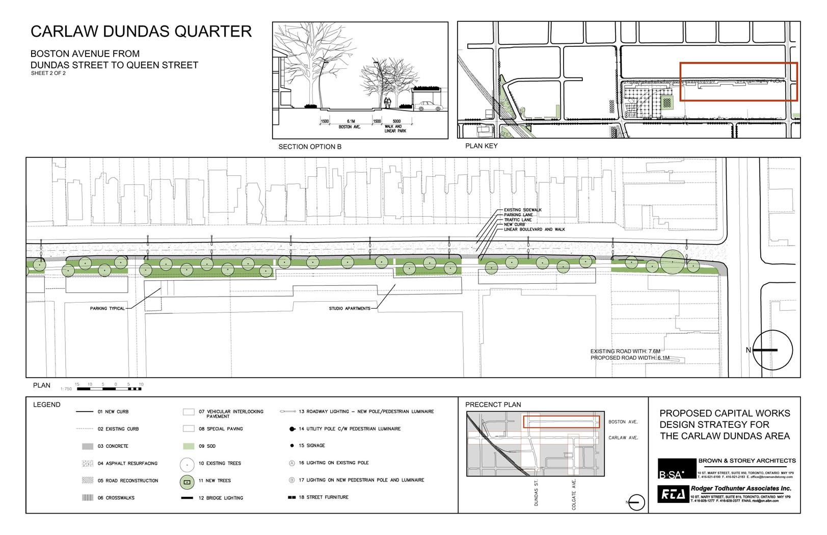
Boston Avenue
Boston Avenue is a north-south street that runs between Queen St. to its south and Dundas St. to its north. A fragmented counterpart of Boston continues north of Dundas to Gerrard. However, this lower section of Boston Ave. is an extremely long block, differentiated as a seam between an industrial western side of the street and a healthy residential eastern edge. Historically, the street has always had this split identity: half industrial, half residential. Efforts to ameliorate this conflict have shown up as attempts to create a planted green boulevard on the western edge of the street to mask the industrial edge and its corresponding parking access issues. These efforts have had limited success; remnants of trees, partial fences have not achieved the original purpose.
We are proposing two options to resolve the Boston Ave. residential/industrial conflict. Both options would result in a more robust boulevard landscape of trees and would include an additional central walk within the boulevard, consequently creating an inside and outside pedestrian walkway. Contributing to this effect is a reduction in the current road width to a better fit, retaining 1 drive lane and 1 street-parking area along its eastern edge. The current road width can be reduced in order to add more space to the western side of the street, appropriate to a one-way street going south.
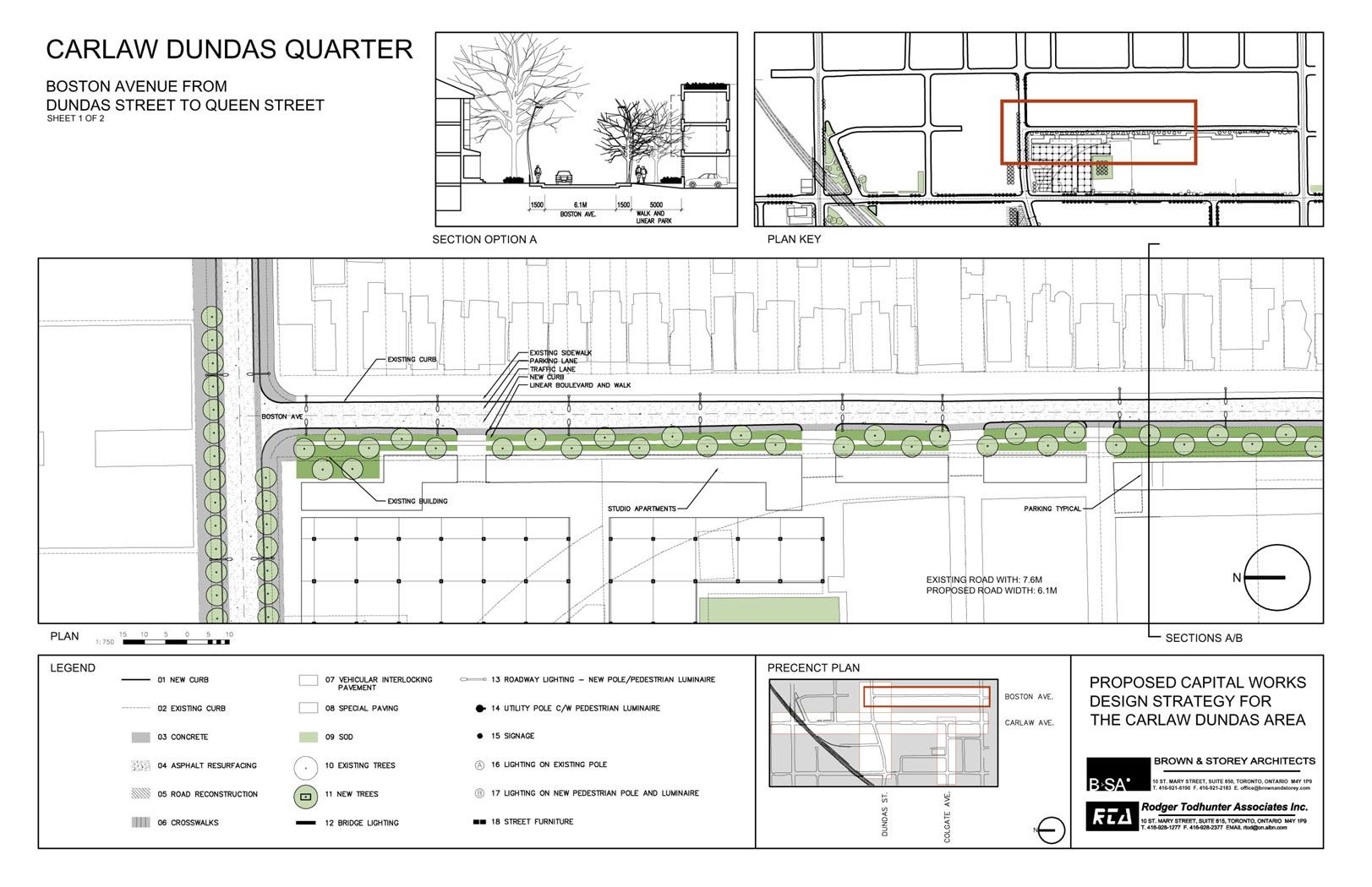
Option A: This option utilizes the new improved linear boulevard idea and improved tree planting, but addresses a larger and perhaps ‘historical’ blindspot that could be resolved by the addition of a finer ‘grain’ studio housing between the larger set-back industrial buildings and the street boulevard edge. Currently, there exists an intermediate zone that varies along this entire stretch of Boston, alternately used as loading and parking for these industrial buildings (currently being renovated for a range of different uses – this same space has lost its original use and significance).
We are proposing a linear studio housing typology for this section, raised up, providing a protected and screened parking area beneath. These 2-storey residential apartments would create a new
frontage and ‘scale’ to complement the existing residential housing along Boston, as well as providing infill housing. These studio apartments would create a new mediated scale with the higher industrial buildings that are adjacent. Entrances to these new apartments could be carefully located along the first open level of the street, providing stair access, storage and building address. The roofs of these apartment structures could also incorporate
Option B: This option suggests that, like Option A, there is a need for a more complex ‘techtonic’ solution to resolve and protect the linear boulevard. In this option, a 1-storey screen trellis structure is proposed, running along the entire edge of the street. The parking is perpendicular to the street and slightly lowered into the grade, creating a condition in which the cars’ lights are masked by a low wall and screen running parallel to the street. This option solves the parking problem along the street, and uses secondary and smaller wall/planting ideas to extend the quality of this side of the street.
Both Option A and Option B could be employed in combination; as well as creating a new capacity for residents to the street and normalizing relations between the two sides of the street. The attempt is to create a healthy incentive to build the linear boulevard, protect it, and create economic potentials that would ensure that private developments contribute to the improvement of the public realm. Healthy spaces would be created where now the street lacks them.
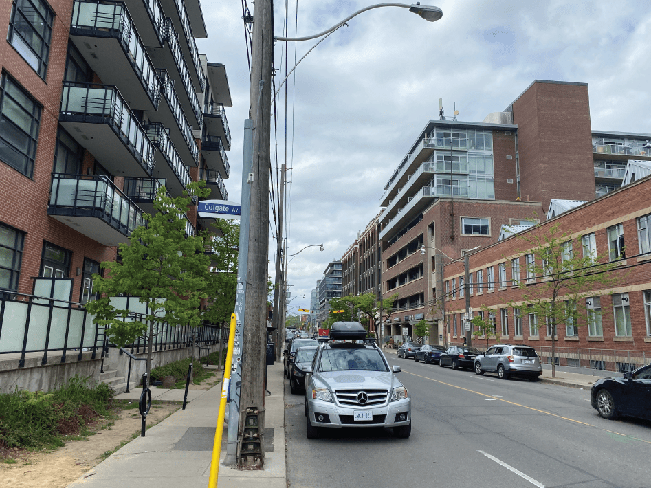
Colgate Avenue
Colgate Avenue is a short discontinuous street that runs east-west, originating at Carlaw Avenue and terminating at Booth Avenue and Jimmy Simpson Park. Currently, the street’s width varies from block to block; at its widest, the street is 12.5 metres, changes to 9.5 metres, and as it moves toward Booth Avenue, it tapers down to 8.0 metres. This varying condition is perhaps related to the former industries and shipping/trucking requirements for wide-turning trucks. The current condition of overly narrow sidewalks and alternating road widths have left the street characterless and in need of an improved identity.
The proposed solution is to normalize the current road width to match the existing most westerly section’s width of approximately 8.0 metres. This would match it to the typical residential streets of the neighbourhood and improve the pedestrian realm with better sidewalks and street tree planting.
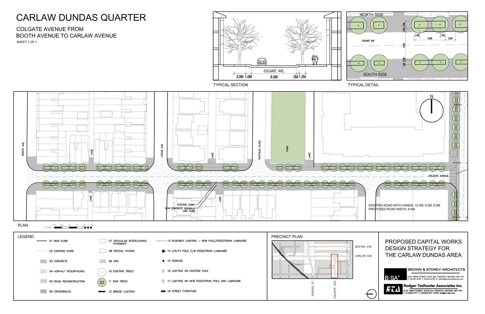
The adjacent Jimmy Simpson Park to the west of Colgate Avenue suggests a good opportunity for connection and greening of the street. Consequently, spacing new trees in open sod verges on both the north and south sides of the street will contribute to the quality of the street’s environment. Paired usage of trees in discontinuous segments allows for pedestrian crossings. These open verges are treated differently on the south side, being somewhat narrower, to take into account the adjacent residential front gardens, whereas the north side has distinctly wider verges and improved sidewalks. Both green verges are set back from the road curb with a protected concrete strip to accommodate parked cars and to ensure the protection of the verge and its maintenance. Colgate Avenue would then have its own unique identity as a residential street and add necessary green to complement the existing parks along its edges.